You are here: Home > Network List > CN - Canadian National Seismograph Network Stations List
> Station DAWY Dawson, YT, CA > Earthquake Result Viewer
DAWY Dawson, YT, CA - Earthquake Result Viewer
| Earthquake location: |
Mariana Islands |
| Earthquake latitude/longitude: |
18.5/145.5 |
| Earthquake time(UTC): |
2016/07/29 (211) 21:18:25 GMT |
| Earthquake Depth: |
212 km |
| Earthquake Magnitude: |
7.7 MWW, 7.7 MWB, 7.7 MI |
| Earthquake Catalog/Contributor: |
NEIC PDE/NEIC COMCAT |
|
| Network: |
CN Canadian National Seismograph Network |
| Station: |
DAWY Dawson, YT, CA |
| Lat/Lon: |
64.06 N/139.39 W |
| Elevation: |
771 m |
|
| Distance: |
67.0 deg |
| Az: |
27.493 deg |
| Baz: |
264.972 deg |
| Ray Param: |
0.05663185 |
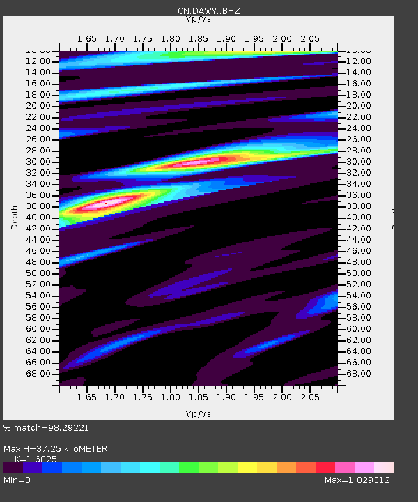
| Estimated Moho Depth: |
37.25 km |
| Estimated Crust Vp/Vs: |
1.68 |
| Assumed Crust Vp: |
6.566 km/s |
| Estimated Crust Vs: |
3.903 km/s |
| Estimated Crust Poisson's Ratio: |
0.23 |
|
| Radial Match: |
98.29221 % |
| Radial Bump: |
376 |
| Transverse Match: |
85.591866 % |
| Transverse Bump: |
400 |
| SOD ConfigId: |
11737051 |
| Insert Time: |
2019-04-25 04:57:18.674 +0000 |
| GWidth: |
2.5 |
| Max Bumps: |
400 |
| Tol: |
0.001 |
|

Signal To Noise
| Channel | StoN | STA | LTA |
| CN:DAWY: :BHZ:20160729T21:28:25.750012Z | 65.95352 | 8.449372E-6 | 1.2811101E-7 |
| CN:DAWY: :BHN:20160729T21:28:25.750012Z | 14.292471 | 5.3812596E-7 | 3.765101E-8 |
| CN:DAWY: :BHE:20160729T21:28:25.750012Z | 76.54503 | 3.7563786E-6 | 4.9074103E-8 |
| Arrivals |
| Ps | 4.0 SECOND |
| PpPs | 15 SECOND |
| PsPs/PpSs | 19 SECOND |


