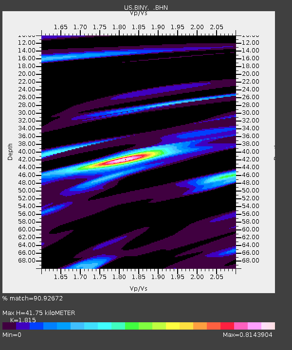
BINY Binghamton, New York, USA - Earthquake Result Viewer

Earthquake location: Near Coast Of Guerrero, Mexico
Earthquake latitude/longitude: 17.0/-100.9
Earthquake time(UTC): 2002/04/18 (108) 05:02:46 GMT
Earthquake Depth: 25 km
Earthquake Magnitude: 5.4 MB, 6.0 MS, 6.3 MW, 6.1 MW
Earthquake Catalog/Contributor: WHDF/NEIC
Network: US United States National Seismic Network
Station: BINY Binghamton, New York, USA
Lat/Lon: 42.20 N/75.99 W
Elevation: 498 m
Distance: 32.9 deg
Az: 35.106 deg
Baz: 227.784 deg
Ray Param: 0.07840998
Estimated Moho Depth: 41.75 km
Estimated Crust Vp/Vs: 1.82
Assumed Crust Vp: 6.419 km/s
Estimated Crust Vs: 3.537 km/s
Estimated Crust Poisson's Ratio: 0.28
Radial Match: 90.92672 %
Radial Bump: 373
Transverse Match: 83.49628 %
Transverse Bump: 400
SOD ConfigId: 110177
Insert Time: 2010-03-05 05:49:10.972 +0000
GWidth: 2.5
Max Bumps: 400
Tol: 0.001

Signal To Noise

ChannelStoNSTALTA
US:BINY: :BHN:20020418T05:08:47.962003Z1.99481832.4528345E-71.2296029E-7
US:BINY: :BHE:20020418T05:08:47.962003Z1.97702733.864459E-71.9546816E-7
US:BINY: :BHZ:20020418T05:08:47.962003Z2.99918321.0228428E-63.4104045E-7
Arrivals
Ps5.7 SECOND
PpPs17 SECOND
PsPs/PpSs23 SECOND