You are here: Home > Network List > CN - Canadian National Seismograph Network Stations List
> Station PNT Penticton, BC, CA > Earthquake Result Viewer
PNT Penticton, BC, CA - Earthquake Result Viewer
| Earthquake location: |
Mariana Islands |
| Earthquake latitude/longitude: |
18.5/145.5 |
| Earthquake time(UTC): |
2016/07/29 (211) 21:18:25 GMT |
| Earthquake Depth: |
212 km |
| Earthquake Magnitude: |
7.7 MWW, 7.7 MWB, 7.7 MI |
| Earthquake Catalog/Contributor: |
NEIC PDE/NEIC COMCAT |
|
| Network: |
CN Canadian National Seismograph Network |
| Station: |
PNT Penticton, BC, CA |
| Lat/Lon: |
49.32 N/119.63 W |
| Elevation: |
531 m |
|
| Distance: |
79.3 deg |
| Az: |
41.574 deg |
| Baz: |
285.777 deg |
| Ray Param: |
0.04854069 |
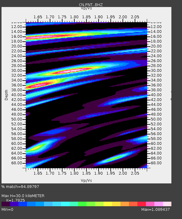
| Estimated Moho Depth: |
30.0 km |
| Estimated Crust Vp/Vs: |
1.78 |
| Assumed Crust Vp: |
6.419 km/s |
| Estimated Crust Vs: |
3.601 km/s |
| Estimated Crust Poisson's Ratio: |
0.27 |
|
| Radial Match: |
94.89797 % |
| Radial Bump: |
400 |
| Transverse Match: |
80.973625 % |
| Transverse Bump: |
400 |
| SOD ConfigId: |
11737051 |
| Insert Time: |
2019-04-25 04:57:35.462 +0000 |
| GWidth: |
2.5 |
| Max Bumps: |
400 |
| Tol: |
0.001 |
|

Signal To Noise
| Channel | StoN | STA | LTA |
| CN:PNT: :BHZ:20160729T21:29:37.425Z | 144.90991 | 8.985643E-6 | 6.2008475E-8 |
| CN:PNT: :BHN:20160729T21:29:37.425Z | 22.46645 | 1.3997847E-6 | 6.230555E-8 |
| CN:PNT: :BHE:20160729T21:29:37.425Z | 44.907413 | 3.4640625E-6 | 7.713788E-8 |
| Arrivals |
| Ps | 3.8 SECOND |
| PpPs | 13 SECOND |
| PsPs/PpSs | 16 SECOND |


