You are here: Home > Network List > US - United States National Seismic Network Stations List
> Station WMOK Wichita Mountains, Oklahoma, USA > Earthquake Result Viewer
WMOK Wichita Mountains, Oklahoma, USA - Earthquake Result Viewer
*The percent match for this event was below the threshold and hence no stack was calculated.
| Earthquake location: |
Near Coast Of Central Chile |
| Earthquake latitude/longitude: |
-31.5/-71.8 |
| Earthquake time(UTC): |
2015/09/17 (260) 04:10:31 GMT |
| Earthquake Depth: |
40 km |
| Earthquake Magnitude: |
6.3 MB |
| Earthquake Catalog/Contributor: |
NEIC PDE/NEIC COMCAT |
|
| Network: |
US United States National Seismic Network |
| Station: |
WMOK Wichita Mountains, Oklahoma, USA |
| Lat/Lon: |
34.74 N/98.78 W |
| Elevation: |
486 m |
|
| Distance: |
70.6 deg |
| Az: |
336.646 deg |
| Baz: |
155.73 deg |
| Ray Param: |
$rayparam |
*The percent match for this event was below the threshold and hence was not used in the summary stack. |
|
| Radial Match: |
79.81068 % |
| Radial Bump: |
387 |
| Transverse Match: |
59.6918 % |
| Transverse Bump: |
400 |
| SOD ConfigId: |
1156111 |
| Insert Time: |
2015-10-01 04:42:23.040 +0000 |
| GWidth: |
2.5 |
| Max Bumps: |
400 |
| Tol: |
0.001 |
|
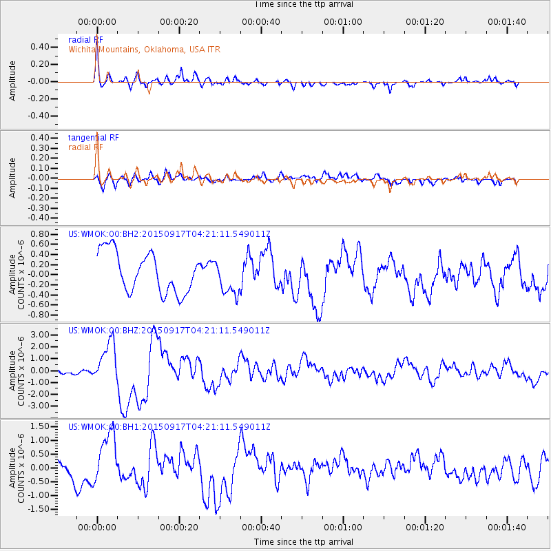
Signal To Noise
| Channel | StoN | STA | LTA |
| US:WMOK:00:BHZ:20150917T04:21:11.549011Z | 7.509451 | 1.7267405E-6 | 2.2994232E-7 |
| US:WMOK:00:BH1:20150917T04:21:11.549011Z | 3.6621406 | 9.95547E-7 | 2.7184836E-7 |
| US:WMOK:00:BH2:20150917T04:21:11.549011Z | 0.88366926 | 3.5535277E-7 | 4.0213325E-7 |
| Arrivals |
| Ps | |
| PpPs | |
| PsPs/PpSs | |


