You are here: Home > Network List > TA - USArray Transportable Network (new EarthScope stations) Stations List
> Station H27K Steamboat Mountain, AK, USA > Earthquake Result Viewer
H27K Steamboat Mountain, AK, USA - Earthquake Result Viewer
| Earthquake location: |
Mariana Islands |
| Earthquake latitude/longitude: |
18.5/145.5 |
| Earthquake time(UTC): |
2016/07/29 (211) 21:18:25 GMT |
| Earthquake Depth: |
212 km |
| Earthquake Magnitude: |
7.7 MWW, 7.7 MWB, 7.7 MI |
| Earthquake Catalog/Contributor: |
NEIC PDE/NEIC COMCAT |
|
| Network: |
TA USArray Transportable Network (new EarthScope stations) |
| Station: |
H27K Steamboat Mountain, AK, USA |
| Lat/Lon: |
66.23 N/141.53 W |
| Elevation: |
786 m |
|
| Distance: |
66.3 deg |
| Az: |
25.029 deg |
| Baz: |
262.063 deg |
| Ray Param: |
0.05704982 |
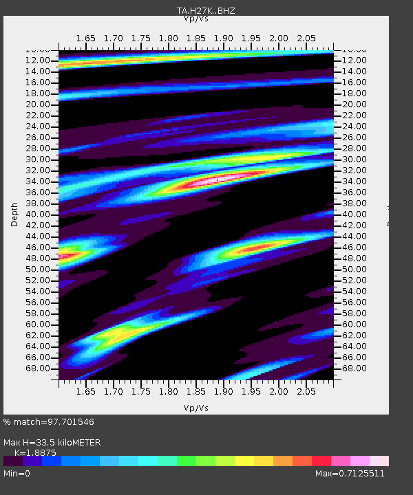
| Estimated Moho Depth: |
33.5 km |
| Estimated Crust Vp/Vs: |
1.89 |
| Assumed Crust Vp: |
6.577 km/s |
| Estimated Crust Vs: |
3.484 km/s |
| Estimated Crust Poisson's Ratio: |
0.30 |
|
| Radial Match: |
97.701546 % |
| Radial Bump: |
400 |
| Transverse Match: |
87.965256 % |
| Transverse Bump: |
400 |
| SOD ConfigId: |
11737051 |
| Insert Time: |
2019-04-25 05:01:46.495 +0000 |
| GWidth: |
2.5 |
| Max Bumps: |
400 |
| Tol: |
0.001 |
|

Signal To Noise
| Channel | StoN | STA | LTA |
| TA:H27K: :BHZ:20160729T21:28:21.649976Z | 122.14839 | 1.15674975E-5 | 9.470037E-8 |
| TA:H27K: :BHN:20160729T21:28:21.649976Z | 29.724104 | 3.0334406E-6 | 1.0205322E-7 |
| TA:H27K: :BHE:20160729T21:28:21.649976Z | 57.606144 | 5.9798763E-6 | 1.0380622E-7 |
| Arrivals |
| Ps | 4.7 SECOND |
| PpPs | 14 SECOND |
| PsPs/PpSs | 19 SECOND |


