You are here: Home > Network List > TA - USArray Transportable Network (new EarthScope stations) Stations List
> Station J29M Klondike Camp, Yukon, CA > Earthquake Result Viewer
J29M Klondike Camp, Yukon, CA - Earthquake Result Viewer
| Earthquake location: |
Mariana Islands |
| Earthquake latitude/longitude: |
18.5/145.5 |
| Earthquake time(UTC): |
2016/07/29 (211) 21:18:25 GMT |
| Earthquake Depth: |
212 km |
| Earthquake Magnitude: |
7.7 MWW, 7.7 MWB, 7.7 MI |
| Earthquake Catalog/Contributor: |
NEIC PDE/NEIC COMCAT |
|
| Network: |
TA USArray Transportable Network (new EarthScope stations) |
| Station: |
J29M Klondike Camp, Yukon, CA |
| Lat/Lon: |
64.45 N/138.22 W |
| Elevation: |
982 m |
|
| Distance: |
67.5 deg |
| Az: |
27.116 deg |
| Baz: |
265.886 deg |
| Ray Param: |
0.056281384 |
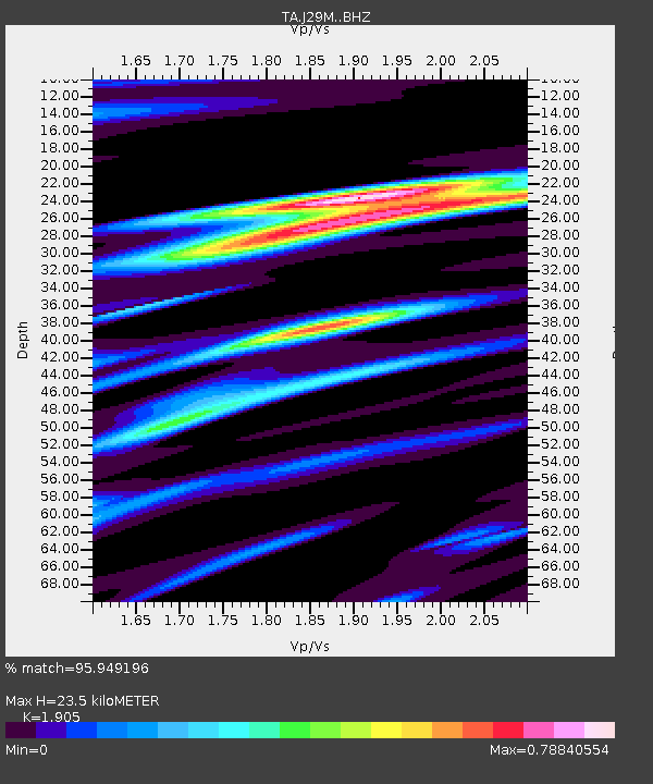
| Estimated Moho Depth: |
23.5 km |
| Estimated Crust Vp/Vs: |
1.90 |
| Assumed Crust Vp: |
6.566 km/s |
| Estimated Crust Vs: |
3.447 km/s |
| Estimated Crust Poisson's Ratio: |
0.31 |
|
| Radial Match: |
95.949196 % |
| Radial Bump: |
400 |
| Transverse Match: |
74.84932 % |
| Transverse Bump: |
400 |
| SOD ConfigId: |
11737051 |
| Insert Time: |
2019-04-25 05:02:00.447 +0000 |
| GWidth: |
2.5 |
| Max Bumps: |
400 |
| Tol: |
0.001 |
|

Signal To Noise
| Channel | StoN | STA | LTA |
| TA:J29M: :BHZ:20160729T21:28:29.149976Z | 35.062283 | 8.453532E-6 | 2.4110045E-7 |
| TA:J29M: :BHN:20160729T21:28:29.149976Z | 11.259946 | 4.369772E-6 | 3.8808108E-7 |
| TA:J29M: :BHE:20160729T21:28:29.149976Z | 23.790516 | 6.6518223E-6 | 2.7959976E-7 |
| Arrivals |
| Ps | 3.4 SECOND |
| PpPs | 10 SECOND |
| PsPs/PpSs | 13 SECOND |


