You are here: Home > Network List > TA - USArray Transportable Network (new EarthScope stations) Stations List
> Station N25K Chitina, Valdez-Cordova, AK, USA > Earthquake Result Viewer
N25K Chitina, Valdez-Cordova, AK, USA - Earthquake Result Viewer
| Earthquake location: |
Mariana Islands |
| Earthquake latitude/longitude: |
18.5/145.5 |
| Earthquake time(UTC): |
2016/07/29 (211) 21:18:25 GMT |
| Earthquake Depth: |
212 km |
| Earthquake Magnitude: |
7.7 MWW, 7.7 MWB, 7.7 MI |
| Earthquake Catalog/Contributor: |
NEIC PDE/NEIC COMCAT |
|
| Network: |
TA USArray Transportable Network (new EarthScope stations) |
| Station: |
N25K Chitina, Valdez-Cordova, AK, USA |
| Lat/Lon: |
61.61 N/144.60 W |
| Elevation: |
1087 m |
|
| Distance: |
64.3 deg |
| Az: |
29.868 deg |
| Baz: |
261.326 deg |
| Ray Param: |
0.058357667 |
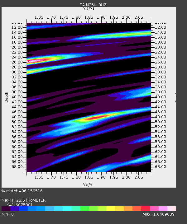
| Estimated Moho Depth: |
25.5 km |
| Estimated Crust Vp/Vs: |
1.61 |
| Assumed Crust Vp: |
6.566 km/s |
| Estimated Crust Vs: |
4.085 km/s |
| Estimated Crust Poisson's Ratio: |
0.18 |
|
| Radial Match: |
96.158516 % |
| Radial Bump: |
400 |
| Transverse Match: |
82.115486 % |
| Transverse Bump: |
400 |
| SOD ConfigId: |
11737051 |
| Insert Time: |
2019-04-25 05:02:25.209 +0000 |
| GWidth: |
2.5 |
| Max Bumps: |
400 |
| Tol: |
0.001 |
|
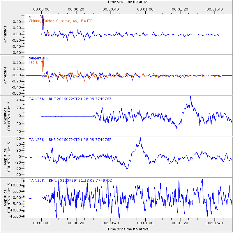
Signal To Noise
| Channel | StoN | STA | LTA |
| TA:N25K: :BHZ:20160729T21:28:08.774976Z | 68.33485 | 8.565426E-6 | 1.2534491E-7 |
| TA:N25K: :BHN:20160729T21:28:08.774976Z | 19.84186 | 1.2977106E-6 | 6.5402666E-8 |
| TA:N25K: :BHE:20160729T21:28:08.774976Z | 44.105656 | 4.0101972E-6 | 9.092251E-8 |
| Arrivals |
| Ps | 2.5 SECOND |
| PpPs | 9.6 SECOND |
| PsPs/PpSs | 12 SECOND |


