You are here: Home > Network List > TA - USArray Transportable Network (new EarthScope stations) Stations List
> Station Q20K Shuyak Island, AK, USA > Earthquake Result Viewer
Q20K Shuyak Island, AK, USA - Earthquake Result Viewer
| Earthquake location: |
Mariana Islands |
| Earthquake latitude/longitude: |
18.5/145.5 |
| Earthquake time(UTC): |
2016/07/29 (211) 21:18:25 GMT |
| Earthquake Depth: |
212 km |
| Earthquake Magnitude: |
7.7 MWW, 7.7 MWB, 7.7 MI |
| Earthquake Catalog/Contributor: |
NEIC PDE/NEIC COMCAT |
|
| Network: |
TA USArray Transportable Network (new EarthScope stations) |
| Station: |
Q20K Shuyak Island, AK, USA |
| Lat/Lon: |
58.61 N/152.39 W |
| Elevation: |
180 m |
|
| Distance: |
59.9 deg |
| Az: |
32.315 deg |
| Baz: |
255.719 deg |
| Ray Param: |
0.06119526 |
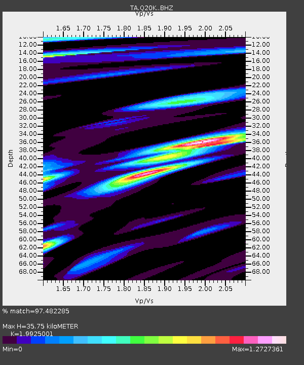
| Estimated Moho Depth: |
35.75 km |
| Estimated Crust Vp/Vs: |
1.99 |
| Assumed Crust Vp: |
5.989 km/s |
| Estimated Crust Vs: |
3.006 km/s |
| Estimated Crust Poisson's Ratio: |
0.33 |
|
| Radial Match: |
97.482285 % |
| Radial Bump: |
335 |
| Transverse Match: |
90.1359 % |
| Transverse Bump: |
400 |
| SOD ConfigId: |
11737051 |
| Insert Time: |
2019-04-25 05:02:41.672 +0000 |
| GWidth: |
2.5 |
| Max Bumps: |
400 |
| Tol: |
0.001 |
|

Signal To Noise
| Channel | StoN | STA | LTA |
| TA:Q20K: :BHZ:20160729T21:27:39.450024Z | 54.521736 | 1.7261886E-5 | 3.1660556E-7 |
| TA:Q20K: :BHN:20160729T21:27:39.450024Z | 10.644946 | 2.322857E-6 | 2.182122E-7 |
| TA:Q20K: :BHE:20160729T21:27:39.450024Z | 29.997128 | 9.731029E-6 | 3.2439868E-7 |
| Arrivals |
| Ps | 6.1 SECOND |
| PpPs | 17 SECOND |
| PsPs/PpSs | 23 SECOND |


