You are here: Home > Network List > XD14 - Illuminating the architecture of the greater Mount St. Helens magmatic systems f Stations List
> Station MA05 "Mount St Helens, WA" > Earthquake Result Viewer
MA05 "Mount St Helens, WA" - Earthquake Result Viewer
| Earthquake location: |
Mariana Islands |
| Earthquake latitude/longitude: |
18.5/145.5 |
| Earthquake time(UTC): |
2016/07/29 (211) 21:18:25 GMT |
| Earthquake Depth: |
212 km |
| Earthquake Magnitude: |
7.7 MWW, 7.7 MWB, 7.7 MI |
| Earthquake Catalog/Contributor: |
NEIC PDE/NEIC COMCAT |
|
| Network: |
XD Illuminating the architecture of the greater Mount St. Helens magmatic systems f |
| Station: |
MA05 "Mount St Helens, WA" |
| Lat/Lon: |
46.75 N/122.23 W |
| Elevation: |
488 m |
|
| Distance: |
78.2 deg |
| Az: |
44.567 deg |
| Baz: |
284.432 deg |
| Ray Param: |
0.04922765 |
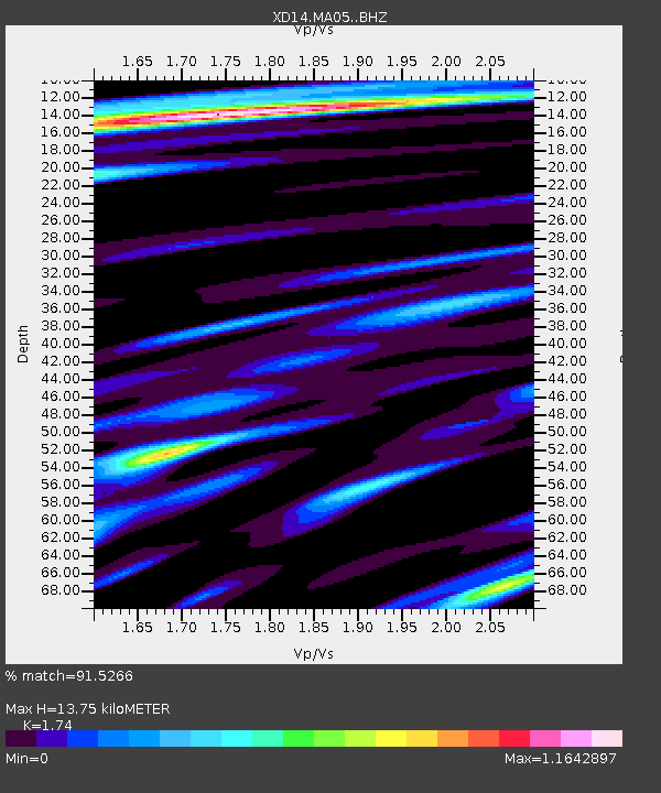
| Estimated Moho Depth: |
13.75 km |
| Estimated Crust Vp/Vs: |
1.74 |
| Assumed Crust Vp: |
6.566 km/s |
| Estimated Crust Vs: |
3.774 km/s |
| Estimated Crust Poisson's Ratio: |
0.25 |
|
| Radial Match: |
91.5266 % |
| Radial Bump: |
400 |
| Transverse Match: |
89.16453 % |
| Transverse Bump: |
400 |
| SOD ConfigId: |
11737051 |
| Insert Time: |
2019-04-25 05:04:05.721 +0000 |
| GWidth: |
2.5 |
| Max Bumps: |
400 |
| Tol: |
0.001 |
|

Signal To Noise
| Channel | StoN | STA | LTA |
| XD:MA05: :BHZ:20160729T21:29:31.899976Z | 83.728516 | 1.4832801E-5 | 1.7715352E-7 |
| XD:MA05: :BHN:20160729T21:29:31.899976Z | 12.513491 | 2.2312956E-6 | 1.7831121E-7 |
| XD:MA05: :BHE:20160729T21:29:31.899976Z | 20.292631 | 4.419547E-6 | 2.1779074E-7 |
| Arrivals |
| Ps | 1.6 SECOND |
| PpPs | 5.6 SECOND |
| PsPs/PpSs | 7.2 SECOND |


