You are here: Home > Network List > GS - US Geological Survey Networks Stations List
> Station KAN10 Keim Farm, Anthony, KS, USA > Earthquake Result Viewer
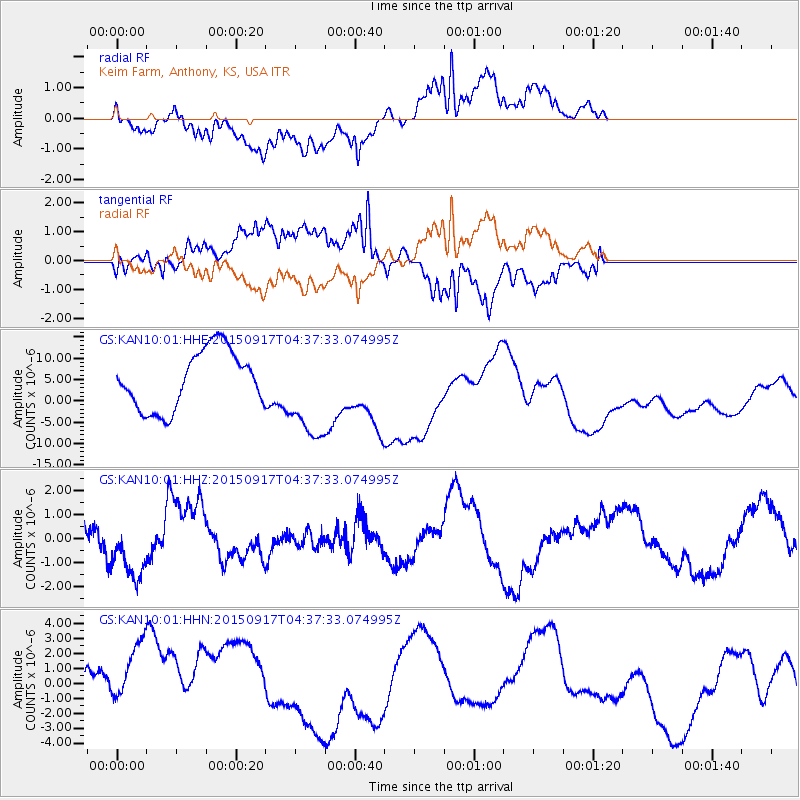
KAN10 Keim Farm, Anthony, KS, USA - Earthquake Result Viewer
*The percent match for this event was below the threshold and hence no stack was calculated.
| Earthquake location: |
Near Coast Of Central Chile |
| Earthquake latitude/longitude: |
-31.4/-72.0 |
| Earthquake time(UTC): |
2015/09/17 (260) 04:26:39 GMT |
| Earthquake Depth: |
18 km |
| Earthquake Magnitude: |
5.5 MB |
| Earthquake Catalog/Contributor: |
NEIC PDE/NEIC COMCAT |
|
| Network: |
GS US Geological Survey Networks |
| Station: |
KAN10 Keim Farm, Anthony, KS, USA |
| Lat/Lon: |
37.12 N/98.10 W |
| Elevation: |
417 m |
|
| Distance: |
72.4 deg |
| Az: |
338.352 deg |
| Baz: |
156.765 deg |
| Ray Param: |
$rayparam |
*The percent match for this event was below the threshold and hence was not used in the summary stack. |
|
| Radial Match: |
58.417744 % |
| Radial Bump: |
400 |
| Transverse Match: |
63.64855 % |
| Transverse Bump: |
400 |
| SOD ConfigId: |
1156111 |
| Insert Time: |
2015-10-01 04:49:44.568 +0000 |
| GWidth: |
2.5 |
| Max Bumps: |
400 |
| Tol: |
0.001 |
|
Signal To Noise
| Channel | StoN | STA | LTA |
| GS:KAN10:01:HHZ:20150917T04:37:33.074995Z | 2.2900782 | 1.238206E-6 | 5.4068283E-7 |
| GS:KAN10:01:HHN:20150917T04:37:33.074995Z | 0.9732772 | 2.9697337E-6 | 3.0512724E-6 |
| GS:KAN10:01:HHE:20150917T04:37:33.074995Z | 1.6354518 | 1.1117796E-5 | 6.797997E-6 |
| Arrivals |
| Ps | |
| PpPs | |
| PsPs/PpSs | |


