You are here: Home > Network List > TA - USArray Transportable Network (new EarthScope stations) Stations List
> Station G22K Bettles, AK, USA > Earthquake Result Viewer
G22K Bettles, AK, USA - Earthquake Result Viewer
| Earthquake location: |
Mariana Islands |
| Earthquake latitude/longitude: |
18.8/145.5 |
| Earthquake time(UTC): |
2016/07/29 (211) 21:26:59 GMT |
| Earthquake Depth: |
188 km |
| Earthquake Magnitude: |
5.6 mb |
| Earthquake Catalog/Contributor: |
NEIC PDE/us |
|
| Network: |
TA USArray Transportable Network (new EarthScope stations) |
| Station: |
G22K Bettles, AK, USA |
| Lat/Lon: |
66.92 N/151.51 W |
| Elevation: |
205 m |
|
| Distance: |
62.4 deg |
| Az: |
23.352 deg |
| Baz: |
252.311 deg |
| Ray Param: |
0.059678845 |
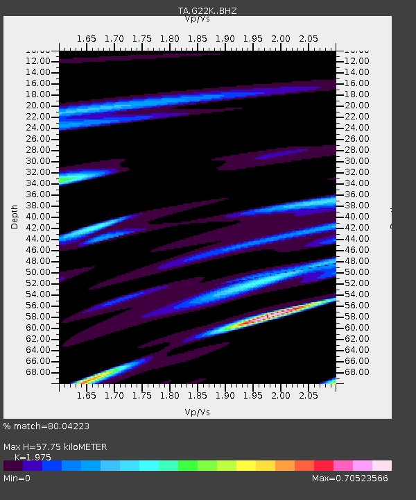
| Estimated Moho Depth: |
57.75 km |
| Estimated Crust Vp/Vs: |
1.98 |
| Assumed Crust Vp: |
6.577 km/s |
| Estimated Crust Vs: |
3.33 km/s |
| Estimated Crust Poisson's Ratio: |
0.33 |
|
| Radial Match: |
80.04223 % |
| Radial Bump: |
304 |
| Transverse Match: |
61.800636 % |
| Transverse Bump: |
358 |
| SOD ConfigId: |
11737051 |
| Insert Time: |
2019-04-25 05:10:27.876 +0000 |
| GWidth: |
2.5 |
| Max Bumps: |
400 |
| Tol: |
0.001 |
|
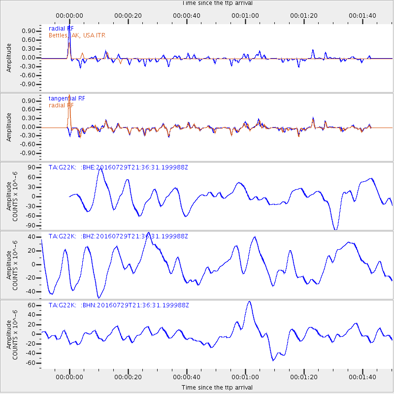
Signal To Noise
| Channel | StoN | STA | LTA |
| TA:G22K: :BHZ:20160729T21:36:31.199988Z | 0.83313495 | 2.766866E-5 | 3.3210297E-5 |
| TA:G22K: :BHN:20160729T21:36:31.199988Z | 0.9519811 | 1.5856933E-5 | 1.6656773E-5 |
| TA:G22K: :BHE:20160729T21:36:31.199988Z | 0.44376224 | 1.706321E-5 | 3.8451242E-5 |
| Arrivals |
| Ps | 8.9 SECOND |
| PpPs | 25 SECOND |
| PsPs/PpSs | 34 SECOND |


