You are here: Home > Network List > CI - Caltech Regional Seismic Network Stations List
> Station MLAC Mammoth Lakes > Earthquake Result Viewer
MLAC Mammoth Lakes - Earthquake Result Viewer
| Earthquake location: |
South Of Fiji Islands |
| Earthquake latitude/longitude: |
-23.6/178.5 |
| Earthquake time(UTC): |
2002/08/19 (231) 11:03:13 GMT |
| Earthquake Depth: |
650 km |
| Earthquake Magnitude: |
5.9 MB |
| Earthquake Catalog/Contributor: |
WHDF/NEIC |
|
| Network: |
CI Caltech Regional Seismic Network |
| Station: |
MLAC Mammoth Lakes |
| Lat/Lon: |
37.63 N/118.84 W |
| Elevation: |
2162 m |
|
| Distance: |
84.6 deg |
| Az: |
45.081 deg |
| Baz: |
234.922 deg |
| Ray Param: |
0.043372948 |
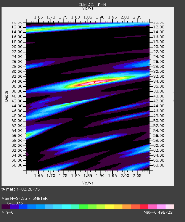
| Estimated Moho Depth: |
34.25 km |
| Estimated Crust Vp/Vs: |
1.88 |
| Assumed Crust Vp: |
6.291 km/s |
| Estimated Crust Vs: |
3.355 km/s |
| Estimated Crust Poisson's Ratio: |
0.30 |
|
| Radial Match: |
82.28775 % |
| Radial Bump: |
400 |
| Transverse Match: |
73.87488 % |
| Transverse Bump: |
400 |
| SOD ConfigId: |
3770 |
| Insert Time: |
2010-02-26 00:37:54.985 +0000 |
| GWidth: |
2.5 |
| Max Bumps: |
400 |
| Tol: |
0.001 |
|

Signal To Noise
| Channel | StoN | STA | LTA |
| CI:MLAC: :BHN:20020819T11:14:09.224995Z | 3.4392028 | 2.2168882E-5 | 6.4459364E-6 |
| CI:MLAC: :BHE:20020819T11:14:09.224995Z | 3.1671133 | 1.24345715E-5 | 3.926153E-6 |
| CI:MLAC: :BHZ:20020819T11:14:09.224995Z | 4.4873137 | 1.7395148E-5 | 3.876517E-6 |
| Arrivals |
| Ps | 4.9 SECOND |
| PpPs | 15 SECOND |
| PsPs/PpSs | 20 SECOND |


