You are here: Home > Network List > CI - Caltech Regional Seismic Network Stations List
> Station MLAC Mammoth Lakes > Earthquake Result Viewer
MLAC Mammoth Lakes - Earthquake Result Viewer
| Earthquake location: |
Fiji Islands Region |
| Earthquake latitude/longitude: |
-16.3/-176.2 |
| Earthquake time(UTC): |
2002/08/09 (221) 13:31:05 GMT |
| Earthquake Depth: |
364 km |
| Earthquake Magnitude: |
5.5 MB, 6.1 MW, 6.1 MW |
| Earthquake Catalog/Contributor: |
WHDF/NEIC |
|
| Network: |
CI Caltech Regional Seismic Network |
| Station: |
MLAC Mammoth Lakes |
| Lat/Lon: |
37.63 N/118.84 W |
| Elevation: |
2162 m |
|
| Distance: |
76.0 deg |
| Az: |
43.537 deg |
| Baz: |
236.421 deg |
| Ray Param: |
0.05024596 |
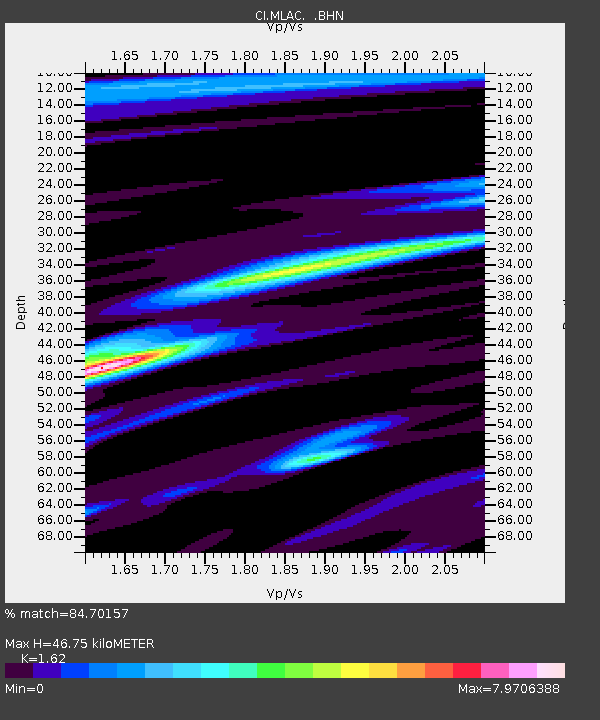
| Estimated Moho Depth: |
46.75 km |
| Estimated Crust Vp/Vs: |
1.62 |
| Assumed Crust Vp: |
6.291 km/s |
| Estimated Crust Vs: |
3.883 km/s |
| Estimated Crust Poisson's Ratio: |
0.19 |
|
| Radial Match: |
84.70157 % |
| Radial Bump: |
400 |
| Transverse Match: |
71.30969 % |
| Transverse Bump: |
400 |
| SOD ConfigId: |
3770 |
| Insert Time: |
2010-02-26 00:37:56.275 +0000 |
| GWidth: |
2.5 |
| Max Bumps: |
400 |
| Tol: |
0.001 |
|

Signal To Noise
| Channel | StoN | STA | LTA |
| CI:MLAC: :BHN:20020809T13:41:42.276023Z | 1.2470076 | 4.925712E-7 | 3.950026E-7 |
| CI:MLAC: :BHE:20020809T13:41:42.276023Z | 1.0589217 | 1.8360944E-7 | 1.7339285E-7 |
| CI:MLAC: :BHZ:20020809T13:41:42.276023Z | 1.0053673 | 1.8471182E-7 | 1.837257E-7 |
| Arrivals |
| Ps | 4.8 SECOND |
| PpPs | 19 SECOND |
| PsPs/PpSs | 24 SECOND |


