You are here: Home > Network List > TA - USArray Transportable Network (new EarthScope stations) Stations List
> Station D25K Kavik River, AK, USA > Earthquake Result Viewer
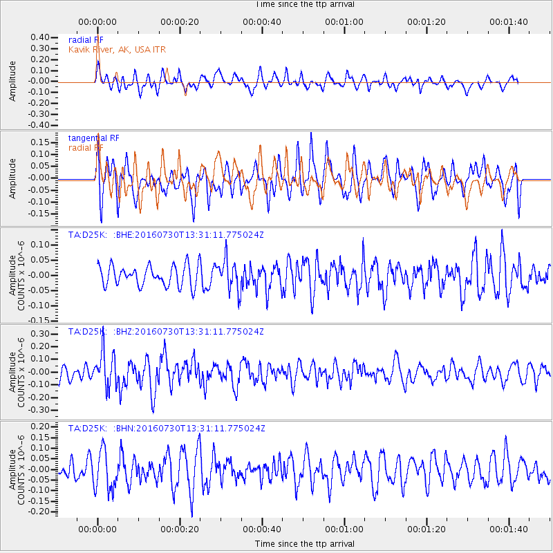
D25K Kavik River, AK, USA - Earthquake Result Viewer
*The percent match for this event was below the threshold and hence no stack was calculated.
| Earthquake location: |
Solomon Islands |
| Earthquake latitude/longitude: |
-6.9/155.8 |
| Earthquake time(UTC): |
2016/07/30 (212) 13:19:10 GMT |
| Earthquake Depth: |
55 km |
| Earthquake Magnitude: |
5.7 MB |
| Earthquake Catalog/Contributor: |
NEIC PDE/NEIC ALERT |
|
| Network: |
TA USArray Transportable Network (new EarthScope stations) |
| Station: |
D25K Kavik River, AK, USA |
| Lat/Lon: |
69.32 N/146.38 W |
| Elevation: |
770 m |
|
| Distance: |
85.7 deg |
| Az: |
17.549 deg |
| Baz: |
237.43 deg |
| Ray Param: |
$rayparam |
*The percent match for this event was below the threshold and hence was not used in the summary stack. |
|
| Radial Match: |
51.38645 % |
| Radial Bump: |
400 |
| Transverse Match: |
49.3007 % |
| Transverse Bump: |
400 |
| SOD ConfigId: |
11737051 |
| Insert Time: |
2019-04-25 05:16:50.761 +0000 |
| GWidth: |
2.5 |
| Max Bumps: |
400 |
| Tol: |
0.001 |
|
Signal To Noise
| Channel | StoN | STA | LTA |
| TA:D25K: :BHZ:20160730T13:31:11.775024Z | 2.7522552 | 1.3916724E-7 | 5.05648E-8 |
| TA:D25K: :BHN:20160730T13:31:11.775024Z | 1.9086369 | 9.312923E-8 | 4.8793584E-8 |
| TA:D25K: :BHE:20160730T13:31:11.775024Z | 1.5836596 | 5.169747E-8 | 3.2644305E-8 |
| Arrivals |
| Ps | |
| PpPs | |
| PsPs/PpSs | |


