You are here: Home > Network List > CI - Caltech Regional Seismic Network Stations List
> Station MLAC Mammoth Lakes > Earthquake Result Viewer
MLAC Mammoth Lakes - Earthquake Result Viewer

| Earthquake location: |
Central Alaska |
| Earthquake latitude/longitude: |
63.5/-147.4 |
| Earthquake time(UTC): |
2002/11/03 (307) 22:12:41 GMT |
| Earthquake Depth: |
4.9 km |
| Earthquake Magnitude: |
7.0 MB, 8.5 MS, 7.9 MW |
| Earthquake Catalog/Contributor: |
WHDF/NEIC |
|
| Network: |
CI Caltech Regional Seismic Network |
| Station: |
MLAC Mammoth Lakes |
| Lat/Lon: |
37.63 N/118.84 W |
| Elevation: |
2162 m |
|
| Distance: |
31.1 deg |
| Az: |
132.673 deg |
| Baz: |
335.469 deg |
| Ray Param: |
0.0791554 |
| Estimated Moho Depth: |
13.5 km |
| Estimated Crust Vp/Vs: |
1.93 |
| Assumed Crust Vp: |
6.291 km/s |
| Estimated Crust Vs: |
3.255 km/s |
| Estimated Crust Poisson's Ratio: |
0.32 |
|
| Radial Match: |
83.46718 % |
| Radial Bump: |
400 |
| Transverse Match: |
73.91279 % |
| Transverse Bump: |
400 |
| SOD ConfigId: |
4714 |
| Insert Time: |
2010-02-26 00:37:57.638 +0000 |
| GWidth: |
2.5 |
| Max Bumps: |
400 |
| Tol: |
0.001 |
|
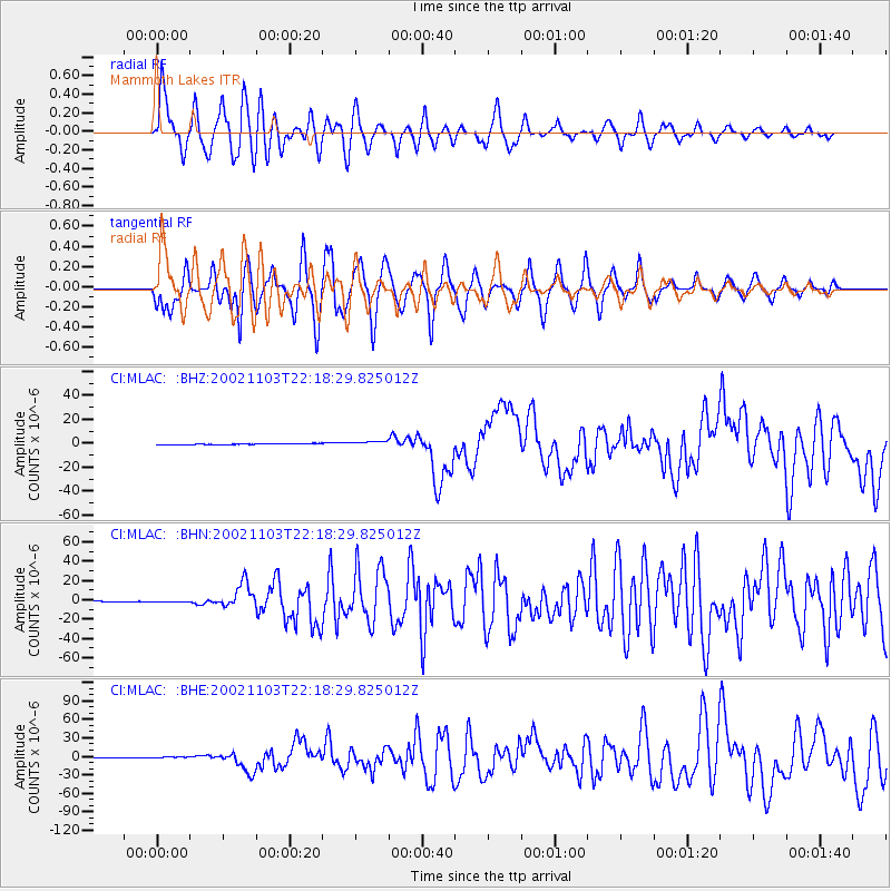
Signal To Noise
| Channel | StoN | STA | LTA |
| CI:MLAC: :BHN:20021103T22:18:29.825012Z | 2.6117303 | 7.6192265E-7 | 2.91731E-7 |
| CI:MLAC: :BHE:20021103T22:18:29.825012Z | 4.121644 | 9.60082E-7 | 2.329367E-7 |
| CI:MLAC: :BHZ:20021103T22:18:29.825012Z | 5.464806 | 1.8899487E-6 | 3.4584005E-7 |
| Arrivals |
| Ps | 2.1 SECOND |
| PpPs | 5.9 SECOND |
| PsPs/PpSs | 8.0 SECOND |


