You are here: Home > Network List > US - United States National Seismic Network Stations List
> Station MVCO Mesa Verde, Colorado, USA > Earthquake Result Viewer
MVCO Mesa Verde, Colorado, USA - Earthquake Result Viewer
| Earthquake location: |
Kuril Islands |
| Earthquake latitude/longitude: |
46.3/153.3 |
| Earthquake time(UTC): |
2006/10/13 (286) 13:47:39 GMT |
| Earthquake Depth: |
8.0 km |
| Earthquake Magnitude: |
5.5 MB, 5.8 MS, 6.3 MW, 5.8 MW |
| Earthquake Catalog/Contributor: |
WHDF/NEIC |
|
| Network: |
US United States National Seismic Network |
| Station: |
MVCO Mesa Verde, Colorado, USA |
| Lat/Lon: |
37.21 N/108.50 W |
| Elevation: |
2170 m |
|
| Distance: |
69.2 deg |
| Az: |
57.672 deg |
| Baz: |
312.74 deg |
| Ray Param: |
0.055779316 |
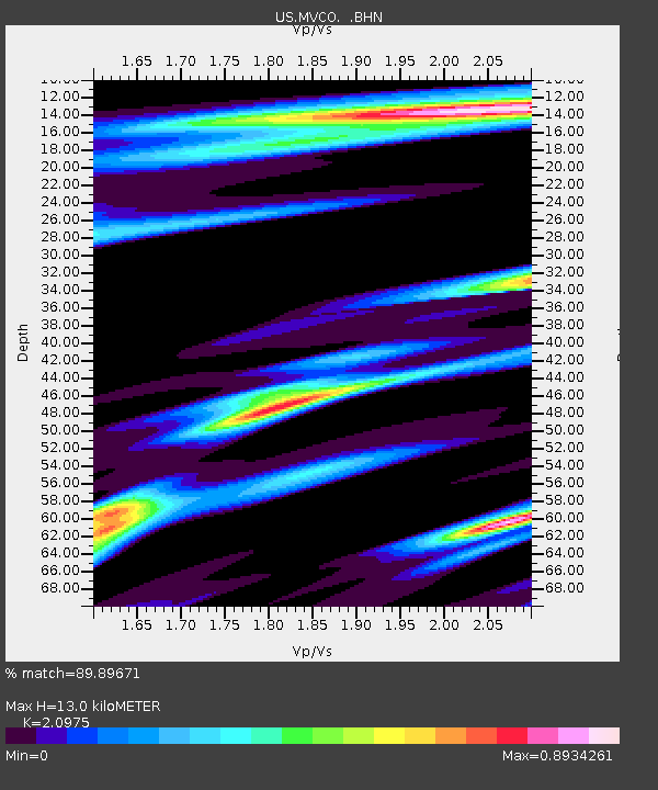
| Estimated Moho Depth: |
13.0 km |
| Estimated Crust Vp/Vs: |
2.10 |
| Assumed Crust Vp: |
6.476 km/s |
| Estimated Crust Vs: |
3.087 km/s |
| Estimated Crust Poisson's Ratio: |
0.35 |
|
| Radial Match: |
89.89671 % |
| Radial Bump: |
400 |
| Transverse Match: |
78.51968 % |
| Transverse Bump: |
395 |
| SOD ConfigId: |
2665 |
| Insert Time: |
2010-03-05 05:53:17.368 +0000 |
| GWidth: |
2.5 |
| Max Bumps: |
400 |
| Tol: |
0.001 |
|

Signal To Noise
| Channel | StoN | STA | LTA |
| US:MVCO: :BHN:20061013T13:58:15.999009Z | 0.61196977 | 1.0181172E-7 | 1.6636724E-7 |
| US:MVCO: :BHE:20061013T13:58:15.999009Z | 1.5704001 | 1.6317358E-7 | 1.0390574E-7 |
| US:MVCO: :BHZ:20061013T13:58:15.999009Z | 4.091534 | 5.757039E-7 | 1.4070612E-7 |
| Arrivals |
| Ps | 2.3 SECOND |
| PpPs | 6.0 SECOND |
| PsPs/PpSs | 8.3 SECOND |


