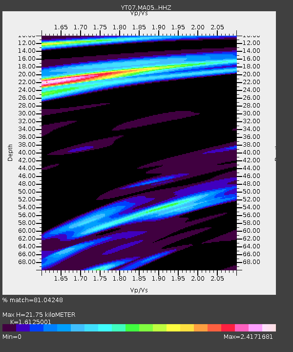
MA05 Polenet mini-array MA05 - Earthquake Result Viewer

Earthquake location: South Sandwich Islands Region
Earthquake latitude/longitude: -56.3/-27.5
Earthquake time(UTC): 2016/07/31 (213) 11:33:20 GMT
Earthquake Depth: 98 km
Earthquake Magnitude: 5.9 MWW, 5.9 MWC, 5.9 MWB
Earthquake Catalog/Contributor: NEIC PDE/NEIC COMCAT
Network: YT POLENET
Station: MA05 Polenet mini-array MA05
Lat/Lon: 78.94 S/97.56 W
Elevation: 1865 m
Distance: 31.7 deg
Az: 200.214 deg
Baz: 87.054 deg
Ray Param: 0.07871737
Estimated Moho Depth: 21.75 km
Estimated Crust Vp/Vs: 1.61
Assumed Crust Vp: 5.833 km/s
Estimated Crust Vs: 3.617 km/s
Estimated Crust Poisson's Ratio: 0.19
Radial Match: 81.04248 %
Radial Bump: 400
Transverse Match: 78.49748 %
Transverse Bump: 400
SOD ConfigId: 11737051
Insert Time: 2019-04-25 05:23:00.474 +0000
GWidth: 2.5
Max Bumps: 400
Tol: 0.001

Signal To Noise

ChannelStoNSTALTA
YT:MA05: :HHZ:20160731T11:39:04.469994Z15.7907312.977365E-61.8855144E-7
YT:MA05: :HHN:20160731T11:39:04.469994Z1.71834622.9451115E-71.713922E-7
YT:MA05: :HHE:20160731T11:39:04.469994Z9.9477038.7181945E-78.7640274E-8
Arrivals
Ps2.5 SECOND
PpPs9.1 SECOND
PsPs/PpSs12 SECOND