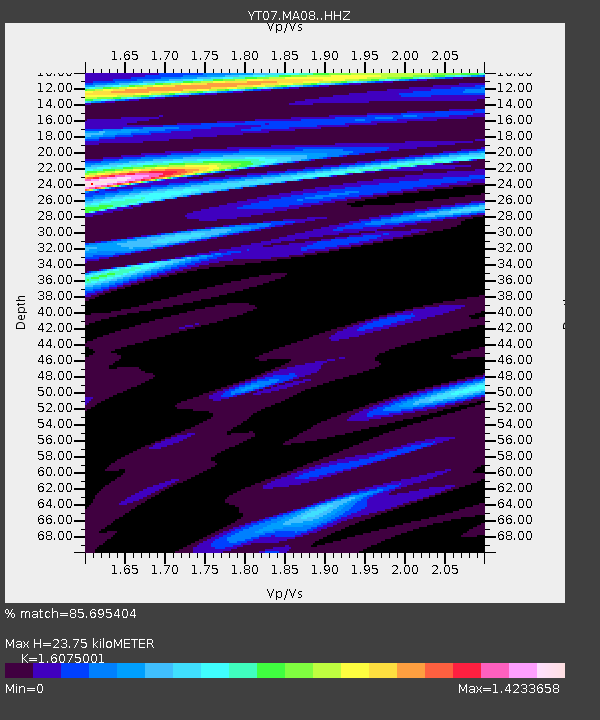
MA08 Polenet mini-array MA08 - Earthquake Result Viewer

Earthquake location: South Sandwich Islands Region
Earthquake latitude/longitude: -56.3/-27.5
Earthquake time(UTC): 2016/07/31 (213) 11:33:20 GMT
Earthquake Depth: 98 km
Earthquake Magnitude: 5.9 MWW, 5.9 MWC, 5.9 MWB
Earthquake Catalog/Contributor: NEIC PDE/NEIC COMCAT
Network: YT POLENET
Station: MA08 Polenet mini-array MA08
Lat/Lon: 77.40 S/103.00 W
Elevation: 1343 m
Distance: 32.8 deg
Az: 203.077 deg
Baz: 94.804 deg
Ray Param: 0.078213215
Estimated Moho Depth: 23.75 km
Estimated Crust Vp/Vs: 1.61
Assumed Crust Vp: 5.836 km/s
Estimated Crust Vs: 3.63 km/s
Estimated Crust Poisson's Ratio: 0.18
Radial Match: 85.695404 %
Radial Bump: 400
Transverse Match: 76.62809 %
Transverse Bump: 400
SOD ConfigId: 11737051
Insert Time: 2019-04-25 05:23:03.215 +0000
GWidth: 2.5
Max Bumps: 400
Tol: 0.001

Signal To Noise

ChannelStoNSTALTA
YT:MA08: :HHZ:20160731T11:39:14.478997Z22.6504654.2794486E-61.8893425E-7
YT:MA08: :HHN:20160731T11:39:14.478997Z1.22227062.4376925E-71.994397E-7
YT:MA08: :HHE:20160731T11:39:14.478997Z7.8509081.2708932E-61.618785E-7
Arrivals
Ps2.7 SECOND
PpPs9.9 SECOND
PsPs/PpSs13 SECOND