You are here: Home > Network List > AV - Alaska Volcano Observatory Stations List
> Station SPCR Ckakachatna River, Mount Spurr, Alaska > Earthquake Result Viewer
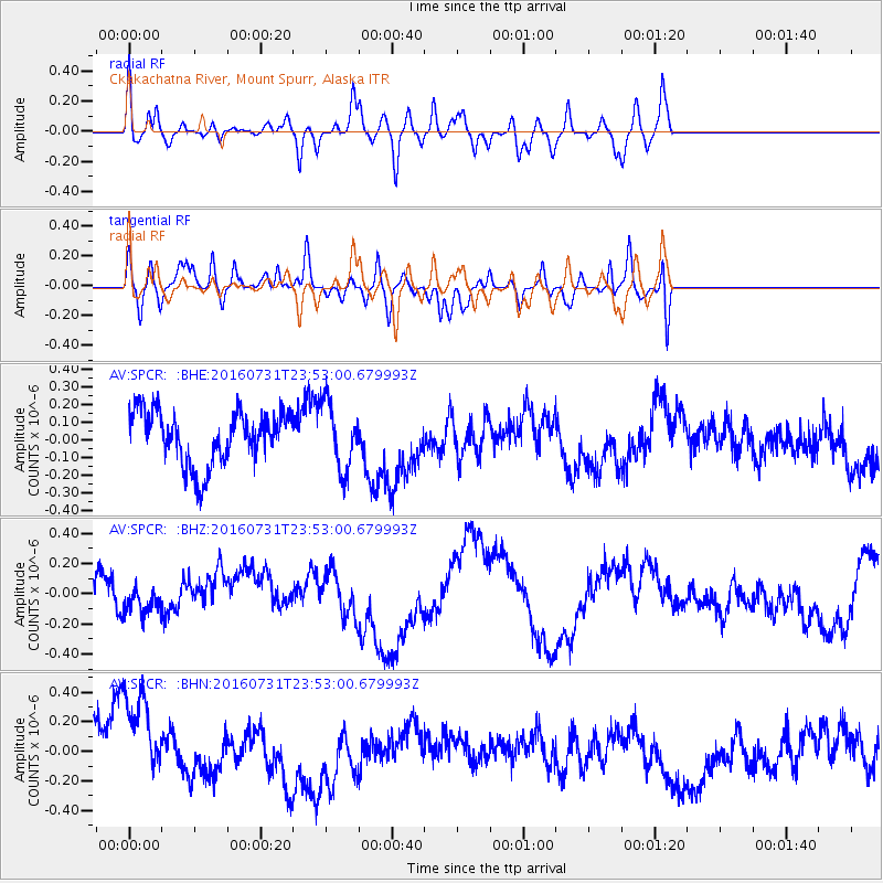
SPCR Ckakachatna River, Mount Spurr, Alaska - Earthquake Result Viewer
*The percent match for this event was below the threshold and hence no stack was calculated.
| Earthquake location: |
Sumbawa Region, Indonesia |
| Earthquake latitude/longitude: |
-8.2/117.8 |
| Earthquake time(UTC): |
2016/07/31 (213) 23:40:00 GMT |
| Earthquake Depth: |
10 km |
| Earthquake Magnitude: |
5.8 MB |
| Earthquake Catalog/Contributor: |
NEIC PDE/NEIC ALERT |
|
| Network: |
AV Alaska Volcano Observatory |
| Station: |
SPCR Ckakachatna River, Mount Spurr, Alaska |
| Lat/Lon: |
61.20 N/152.21 W |
| Elevation: |
984 m |
|
| Distance: |
97.1 deg |
| Az: |
29.21 deg |
| Baz: |
266.005 deg |
| Ray Param: |
$rayparam |
*The percent match for this event was below the threshold and hence was not used in the summary stack. |
|
| Radial Match: |
60.32253 % |
| Radial Bump: |
400 |
| Transverse Match: |
61.84681 % |
| Transverse Bump: |
400 |
| SOD ConfigId: |
11737051 |
| Insert Time: |
2019-04-25 05:24:16.904 +0000 |
| GWidth: |
2.5 |
| Max Bumps: |
400 |
| Tol: |
0.001 |
|
Signal To Noise
| Channel | StoN | STA | LTA |
| AV:SPCR: :BHZ:20160731T23:53:00.679993Z | 0.69969445 | 7.649813E-8 | 1.0933076E-7 |
| AV:SPCR: :BHN:20160731T23:53:00.679993Z | 2.5479834 | 3.371627E-7 | 1.3232531E-7 |
| AV:SPCR: :BHE:20160731T23:53:00.679993Z | 1.2860671 | 1.9064267E-7 | 1.4823695E-7 |
| Arrivals |
| Ps | |
| PpPs | |
| PsPs/PpSs | |


