You are here: Home > Network List > CI - Caltech Regional Seismic Network Stations List
> Station MLAC Mammoth Lakes, California, USA > Earthquake Result Viewer
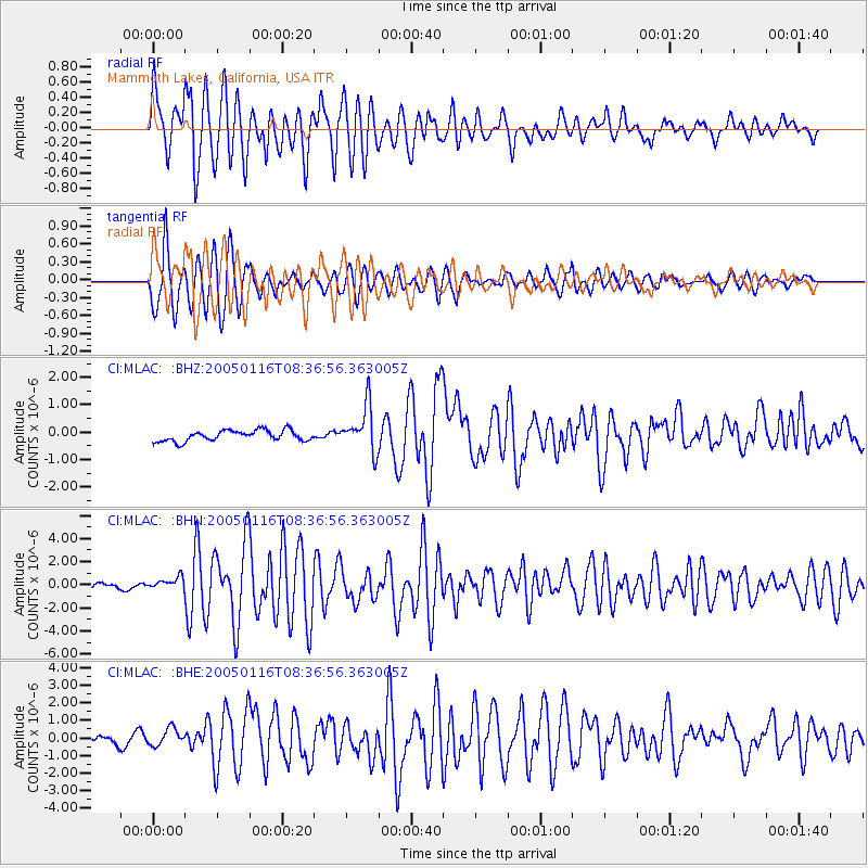
MLAC Mammoth Lakes, California, USA - Earthquake Result Viewer

| Earthquake location: |
South Of Fiji Islands |
| Earthquake latitude/longitude: |
-25.5/-176.3 |
| Earthquake time(UTC): |
2005/01/16 (016) 08:25:04 GMT |
| Earthquake Depth: |
16 km |
| Earthquake Magnitude: |
6.0 MB, 6.1 MS, 6.2 MW, 6.1 MW |
| Earthquake Catalog/Contributor: |
WHDF/NEIC |
|
| Network: |
CI Caltech Regional Seismic Network |
| Station: |
MLAC Mammoth Lakes, California, USA |
| Lat/Lon: |
37.63 N/118.84 W |
| Elevation: |
2134 m |
|
| Distance: |
82.8 deg |
| Az: |
42.426 deg |
| Baz: |
230.15 deg |
| Ray Param: |
0.04662101 |
| Estimated Moho Depth: |
24.75 km |
| Estimated Crust Vp/Vs: |
1.85 |
| Assumed Crust Vp: |
6.291 km/s |
| Estimated Crust Vs: |
3.405 km/s |
| Estimated Crust Poisson's Ratio: |
0.29 |
|
| Radial Match: |
81.718544 % |
| Radial Bump: |
400 |
| Transverse Match: |
85.70711 % |
| Transverse Bump: |
400 |
| SOD ConfigId: |
5233 |
| Insert Time: |
2010-02-26 00:38:04.351 +0000 |
| GWidth: |
2.5 |
| Max Bumps: |
400 |
| Tol: |
0.001 |
|
Signal To Noise
| Channel | StoN | STA | LTA |
| CI:MLAC: :BHN:20050116T08:36:56.363005Z | 1.8241045 | 6.7425196E-7 | 3.696345E-7 |
| CI:MLAC: :BHE:20050116T08:36:56.363005Z | 1.1727568 | 4.99289E-7 | 4.257396E-7 |
| CI:MLAC: :BHZ:20050116T08:36:56.363005Z | 4.2615604 | 8.342139E-7 | 1.9575315E-7 |
| Arrivals |
| Ps | 3.4 SECOND |
| PpPs | 11 SECOND |
| PsPs/PpSs | 14 SECOND |


