You are here: Home > Network List > MM - Myanmar National Seismic Network Stations List
> Station TMU Tamu, Sagaing, Myanmar > Earthquake Result Viewer
TMU Tamu, Sagaing, Myanmar - Earthquake Result Viewer
| Earthquake location: |
South Indian Ocean |
| Earthquake latitude/longitude: |
-24.0/82.5 |
| Earthquake time(UTC): |
2016/08/01 (214) 07:42:51 GMT |
| Earthquake Depth: |
10 km |
| Earthquake Magnitude: |
6.1 MB |
| Earthquake Catalog/Contributor: |
NEIC PDE/NEIC ALERT |
|
| Network: |
MM Myanmar National Seismic Network |
| Station: |
TMU Tamu, Sagaing, Myanmar |
| Lat/Lon: |
24.23 N/94.30 E |
| Elevation: |
182 m |
|
| Distance: |
49.3 deg |
| Az: |
14.291 deg |
| Baz: |
194.321 deg |
| Ray Param: |
0.06881437 |
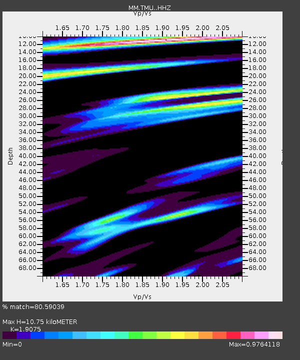
| Estimated Moho Depth: |
10.75 km |
| Estimated Crust Vp/Vs: |
1.91 |
| Assumed Crust Vp: |
6.316 km/s |
| Estimated Crust Vs: |
3.311 km/s |
| Estimated Crust Poisson's Ratio: |
0.31 |
|
| Radial Match: |
80.59039 % |
| Radial Bump: |
326 |
| Transverse Match: |
74.06847 % |
| Transverse Bump: |
353 |
| SOD ConfigId: |
11737051 |
| Insert Time: |
2019-04-25 05:29:06.362 +0000 |
| GWidth: |
2.5 |
| Max Bumps: |
400 |
| Tol: |
0.001 |
|

Signal To Noise
| Channel | StoN | STA | LTA |
| MM:TMU: :HHZ:20160801T07:51:08.877991Z | 13.370117 | 1.2267941E-6 | 9.175642E-8 |
| MM:TMU: :HHN:20160801T07:51:08.877991Z | 9.411989 | 8.8787357E-7 | 9.4334325E-8 |
| MM:TMU: :HHE:20160801T07:51:08.877991Z | 2.6416404 | 2.0777946E-7 | 7.865546E-8 |
| Arrivals |
| Ps | 1.6 SECOND |
| PpPs | 4.7 SECOND |
| PsPs/PpSs | 6.3 SECOND |


