You are here: Home > Network List > US - United States National Seismic Network Stations List
> Station AMTX Amarillo, Texas, USA > Earthquake Result Viewer
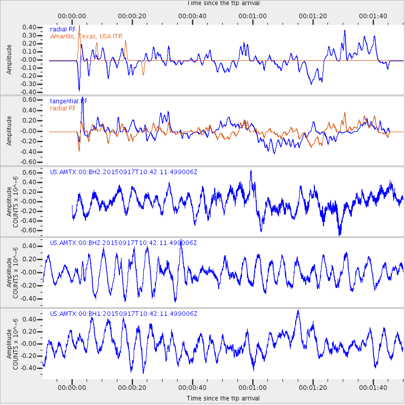
AMTX Amarillo, Texas, USA - Earthquake Result Viewer
*The percent match for this event was below the threshold and hence no stack was calculated.
| Earthquake location: |
Near Coast Of Central Chile |
| Earthquake latitude/longitude: |
-31.0/-71.4 |
| Earthquake time(UTC): |
2015/09/17 (260) 10:31:26 GMT |
| Earthquake Depth: |
42 km |
| Earthquake Magnitude: |
5.5 MB |
| Earthquake Catalog/Contributor: |
NEIC PDE/NEIC COMCAT |
|
| Network: |
US United States National Seismic Network |
| Station: |
AMTX Amarillo, Texas, USA |
| Lat/Lon: |
34.53 N/101.41 W |
| Elevation: |
1010 m |
|
| Distance: |
71.0 deg |
| Az: |
334.113 deg |
| Baz: |
152.99 deg |
| Ray Param: |
$rayparam |
*The percent match for this event was below the threshold and hence was not used in the summary stack. |
|
| Radial Match: |
43.593105 % |
| Radial Bump: |
400 |
| Transverse Match: |
53.857727 % |
| Transverse Bump: |
400 |
| SOD ConfigId: |
1156111 |
| Insert Time: |
2015-10-01 10:43:07.827 +0000 |
| GWidth: |
2.5 |
| Max Bumps: |
400 |
| Tol: |
0.001 |
|
Signal To Noise
| Channel | StoN | STA | LTA |
| US:AMTX:00:BHZ:20150917T10:42:11.499006Z | 0.6405699 | 1.0343649E-7 | 1.6147573E-7 |
| US:AMTX:00:BH1:20150917T10:42:11.499006Z | 0.7193946 | 1.2049688E-7 | 1.674976E-7 |
| US:AMTX:00:BH2:20150917T10:42:11.499006Z | 0.95868576 | 1.656755E-7 | 1.7281525E-7 |
| Arrivals |
| Ps | |
| PpPs | |
| PsPs/PpSs | |


