You are here: Home > Network List > N4 - Central and EAstern US Network Stations List
> Station L42A Oliver, Polo, IL, USA > Earthquake Result Viewer
L42A Oliver, Polo, IL, USA - Earthquake Result Viewer
| Earthquake location: |
Jujuy Province, Argentina |
| Earthquake latitude/longitude: |
-22.4/-66.0 |
| Earthquake time(UTC): |
2016/08/04 (217) 14:15:11 GMT |
| Earthquake Depth: |
258 km |
| Earthquake Magnitude: |
6.0 MO |
| Earthquake Catalog/Contributor: |
NEIC PDE/NEIC ALERT |
|
| Network: |
N4 Central and EAstern US Network |
| Station: |
L42A Oliver, Polo, IL, USA |
| Lat/Lon: |
42.00 N/89.67 W |
| Elevation: |
257 m |
|
| Distance: |
67.7 deg |
| Az: |
341.129 deg |
| Baz: |
156.319 deg |
| Ray Param: |
0.056013364 |
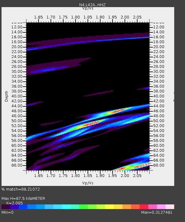
| Estimated Moho Depth: |
67.5 km |
| Estimated Crust Vp/Vs: |
2.09 |
| Assumed Crust Vp: |
6.571 km/s |
| Estimated Crust Vs: |
3.151 km/s |
| Estimated Crust Poisson's Ratio: |
0.35 |
|
| Radial Match: |
86.21072 % |
| Radial Bump: |
400 |
| Transverse Match: |
55.69777 % |
| Transverse Bump: |
400 |
| SOD ConfigId: |
11737051 |
| Insert Time: |
2019-04-25 05:39:19.982 +0000 |
| GWidth: |
2.5 |
| Max Bumps: |
400 |
| Tol: |
0.001 |
|

Signal To Noise
| Channel | StoN | STA | LTA |
| N4:L42A: :HHZ:20160804T14:25:10.109985Z | 8.169919 | 4.990504E-7 | 6.108388E-8 |
| N4:L42A: :HHN:20160804T14:25:10.109985Z | 2.0795949 | 2.0417745E-7 | 9.818136E-8 |
| N4:L42A: :HHE:20160804T14:25:10.109985Z | 1.7368999 | 1.2924987E-7 | 7.441412E-8 |
| Arrivals |
| Ps | 12 SECOND |
| PpPs | 31 SECOND |
| PsPs/PpSs | 42 SECOND |


