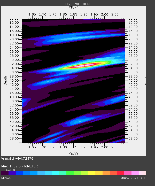
COWI Conover, Wisconsin, USA - Earthquake Result Viewer

Earthquake location: Near West Coast Of Honshu, Japan
Earthquake latitude/longitude: 37.3/136.6
Earthquake time(UTC): 2007/03/25 (084) 00:41:57 GMT
Earthquake Depth: 8.0 km
Earthquake Magnitude: 6.1 MB, 6.8 MS, 6.7 MW, 6.6 MW
Earthquake Catalog/Contributor: WHDF/NEIC
Network: US United States National Seismic Network
Station: COWI Conover, Wisconsin, USA
Lat/Lon: 46.10 N/89.14 W
Elevation: 523 m
Distance: 87.3 deg
Az: 29.917 deg
Baz: 325.159 deg
Ray Param: 0.04340257
Estimated Moho Depth: 32.5 km
Estimated Crust Vp/Vs: 1.90
Assumed Crust Vp: 6.467 km/s
Estimated Crust Vs: 3.404 km/s
Estimated Crust Poisson's Ratio: 0.31
Radial Match: 94.72476 %
Radial Bump: 400
Transverse Match: 82.103745 %
Transverse Bump: 400
SOD ConfigId: 2564
Insert Time: 2010-03-05 05:55:41.707 +0000
GWidth: 2.5
Max Bumps: 400
Tol: 0.001

Signal To Noise

ChannelStoNSTALTA
US:COWI: :BHN:20070325T00:54:13.600029Z5.76880658.03916E-71.3935569E-7
US:COWI: :BHE:20070325T00:54:13.600029Z9.8097027.7682944E-77.918991E-8
US:COWI: :BHZ:20070325T00:54:13.600029Z25.7379263.1159384E-61.2106408E-7
Arrivals
Ps4.6 SECOND
PpPs14 SECOND
PsPs/PpSs19 SECOND