You are here: Home > Network List > TA - USArray Transportable Network (new EarthScope stations) Stations List
> Station H17A Grant Village (NPS), Yellowstone Nt. Park, WY, USA > Earthquake Result Viewer
H17A Grant Village (NPS), Yellowstone Nt. Park, WY, USA - Earthquake Result Viewer
| Earthquake location: |
Jujuy Province, Argentina |
| Earthquake latitude/longitude: |
-22.4/-66.0 |
| Earthquake time(UTC): |
2016/08/04 (217) 14:15:11 GMT |
| Earthquake Depth: |
258 km |
| Earthquake Magnitude: |
6.0 MO |
| Earthquake Catalog/Contributor: |
NEIC PDE/NEIC ALERT |
|
| Network: |
TA USArray Transportable Network (new EarthScope stations) |
| Station: |
H17A Grant Village (NPS), Yellowstone Nt. Park, WY, USA |
| Lat/Lon: |
44.40 N/110.58 W |
| Elevation: |
2400 m |
|
| Distance: |
78.0 deg |
| Az: |
329.035 deg |
| Baz: |
138.373 deg |
| Ray Param: |
0.04928508 |
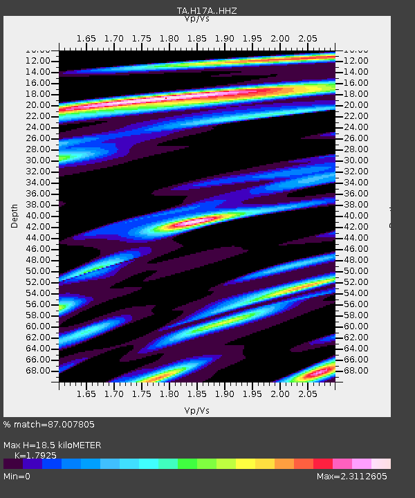
| Estimated Moho Depth: |
18.5 km |
| Estimated Crust Vp/Vs: |
1.79 |
| Assumed Crust Vp: |
6.35 km/s |
| Estimated Crust Vs: |
3.543 km/s |
| Estimated Crust Poisson's Ratio: |
0.27 |
|
| Radial Match: |
87.007805 % |
| Radial Bump: |
400 |
| Transverse Match: |
82.647835 % |
| Transverse Bump: |
400 |
| SOD ConfigId: |
11737051 |
| Insert Time: |
2019-04-25 05:43:19.427 +0000 |
| GWidth: |
2.5 |
| Max Bumps: |
400 |
| Tol: |
0.001 |
|

Signal To Noise
| Channel | StoN | STA | LTA |
| TA:H17A: :HHZ:20160804T14:26:09.98999Z | 2.2517042 | 1.4471367E-7 | 6.4268505E-8 |
| TA:H17A: :HHN:20160804T14:26:09.98999Z | 2.276232 | 1.6186736E-7 | 7.111198E-8 |
| TA:H17A: :HHE:20160804T14:26:09.98999Z | 2.0458515 | 1.2704186E-7 | 6.20973E-8 |
| Arrivals |
| Ps | 2.4 SECOND |
| PpPs | 7.9 SECOND |
| PsPs/PpSs | 10 SECOND |


