You are here: Home > Network List > TA - USArray Transportable Network (new EarthScope stations) Stations List
> Station TUL1 Leonard, OK, USA > Earthquake Result Viewer
TUL1 Leonard, OK, USA - Earthquake Result Viewer
| Earthquake location: |
Jujuy Province, Argentina |
| Earthquake latitude/longitude: |
-22.4/-66.0 |
| Earthquake time(UTC): |
2016/08/04 (217) 14:15:11 GMT |
| Earthquake Depth: |
258 km |
| Earthquake Magnitude: |
6.0 MO |
| Earthquake Catalog/Contributor: |
NEIC PDE/NEIC ALERT |
|
| Network: |
TA USArray Transportable Network (new EarthScope stations) |
| Station: |
TUL1 Leonard, OK, USA |
| Lat/Lon: |
35.91 N/95.79 W |
| Elevation: |
256 m |
|
| Distance: |
64.5 deg |
| Az: |
333.445 deg |
| Baz: |
149.357 deg |
| Ray Param: |
0.058095835 |
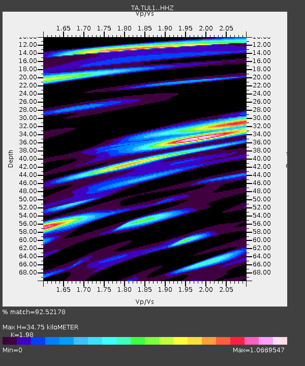
| Estimated Moho Depth: |
34.75 km |
| Estimated Crust Vp/Vs: |
1.98 |
| Assumed Crust Vp: |
6.498 km/s |
| Estimated Crust Vs: |
3.282 km/s |
| Estimated Crust Poisson's Ratio: |
0.33 |
|
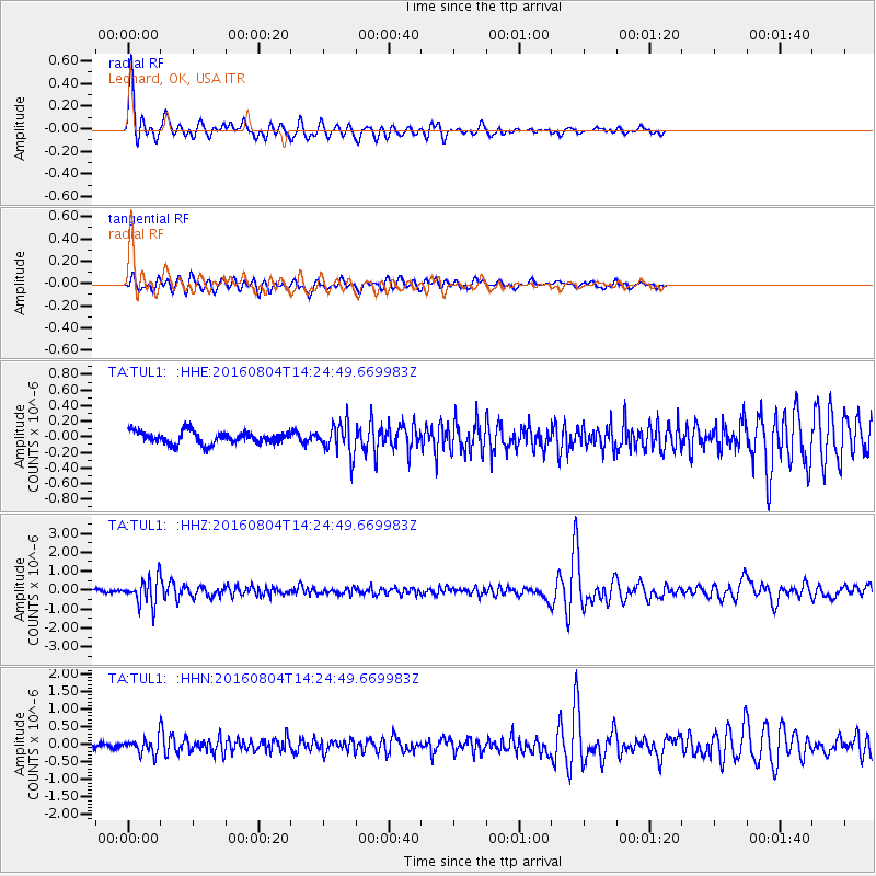
| Radial Match: |
92.52178 % |
| Radial Bump: |
400 |
| Transverse Match: |
83.14815 % |
| Transverse Bump: |
400 |
| SOD ConfigId: |
11737051 |
| Insert Time: |
2019-04-25 05:43:42.168 +0000 |
| GWidth: |
2.5 |
| Max Bumps: |
400 |
| Tol: |
0.001 |
|
Signal To Noise
| Channel | StoN | STA | LTA |
| TA:TUL1: :HHZ:20160804T14:24:49.669983Z | 8.644438 | 6.829574E-7 | 7.900542E-8 |
| TA:TUL1: :HHN:20160804T14:24:49.669983Z | 3.2232683 | 2.2676157E-7 | 7.035144E-8 |
| TA:TUL1: :HHE:20160804T14:24:49.669983Z | 2.3911064 | 1.8697123E-7 | 7.819444E-8 |
| Arrivals |
| Ps | 5.4 SECOND |
| PpPs | 15 SECOND |
| PsPs/PpSs | 21 SECOND |


