You are here: Home > Network List > TA - USArray Transportable Network (new EarthScope stations) Stations List
> Station WHTX Lake Whitney, Meridian, TX, USA > Earthquake Result Viewer
WHTX Lake Whitney, Meridian, TX, USA - Earthquake Result Viewer

| Earthquake location: |
Jujuy Province, Argentina |
| Earthquake latitude/longitude: |
-22.4/-66.0 |
| Earthquake time(UTC): |
2016/08/04 (217) 14:15:11 GMT |
| Earthquake Depth: |
258 km |
| Earthquake Magnitude: |
6.0 MO |
| Earthquake Catalog/Contributor: |
NEIC PDE/NEIC ALERT |
|
| Network: |
TA USArray Transportable Network (new EarthScope stations) |
| Station: |
WHTX Lake Whitney, Meridian, TX, USA |
| Lat/Lon: |
31.99 N/97.46 W |
| Elevation: |
190 m |
|
| Distance: |
61.9 deg |
| Az: |
329.814 deg |
| Baz: |
146.792 deg |
| Ray Param: |
0.059753478 |
| Estimated Moho Depth: |
43.25 km |
| Estimated Crust Vp/Vs: |
1.70 |
| Assumed Crust Vp: |
6.347 km/s |
| Estimated Crust Vs: |
3.728 km/s |
| Estimated Crust Poisson's Ratio: |
0.24 |
|
| Radial Match: |
83.08893 % |
| Radial Bump: |
400 |
| Transverse Match: |
79.54335 % |
| Transverse Bump: |
400 |
| SOD ConfigId: |
11737051 |
| Insert Time: |
2019-04-25 05:43:42.450 +0000 |
| GWidth: |
2.5 |
| Max Bumps: |
400 |
| Tol: |
0.001 |
|
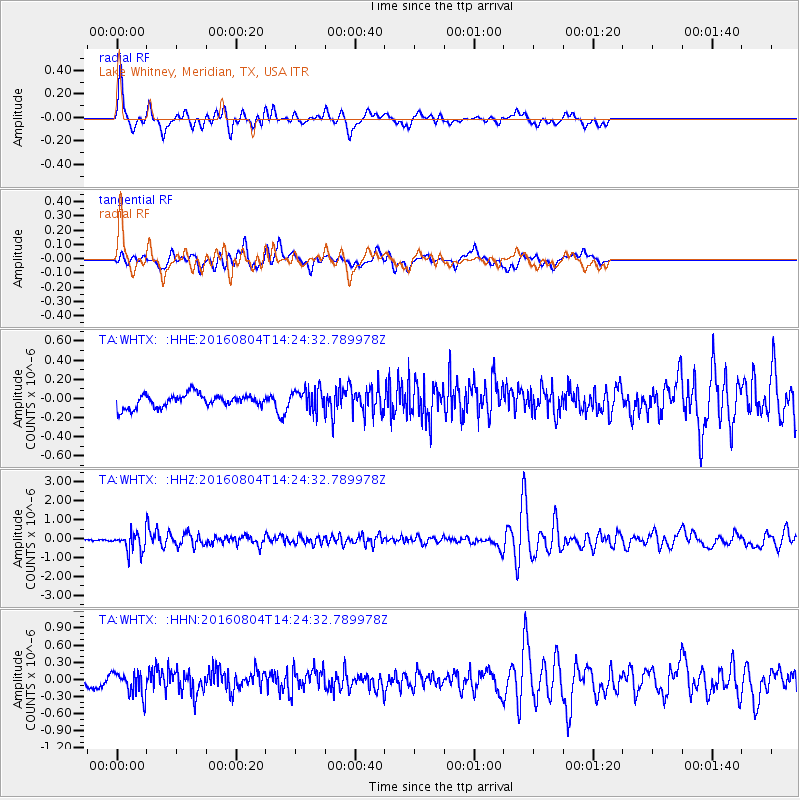
Signal To Noise
| Channel | StoN | STA | LTA |
| TA:WHTX: :HHZ:20160804T14:24:32.789978Z | 5.3966846 | 4.9880276E-7 | 9.2427626E-8 |
| TA:WHTX: :HHN:20160804T14:24:32.789978Z | 2.2445257 | 2.0892905E-7 | 9.3083834E-8 |
| TA:WHTX: :HHE:20160804T14:24:32.789978Z | 1.6445942 | 1.1406307E-7 | 6.935636E-8 |
| Arrivals |
| Ps | 5.0 SECOND |
| PpPs | 18 SECOND |
| PsPs/PpSs | 23 SECOND |


