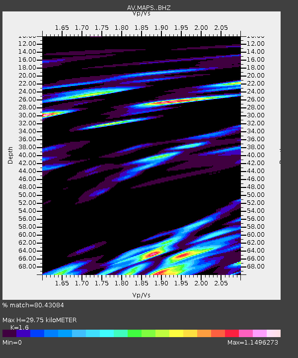
MAPS Pakushin Southeast, Makushin Volcano, Alaska - Earthquake Result Viewer

Earthquake location: Volcano Islands, Japan Region
Earthquake latitude/longitude: 24.9/142.0
Earthquake time(UTC): 2016/08/04 (217) 16:24:33 GMT
Earthquake Depth: 510 km
Earthquake Magnitude: 6.3 MWW, 6.2 MWC, 6.3 MWB, 6.3 MWC
Earthquake Catalog/Contributor: NEIC PDE/NEIC COMCAT
Network: AV Alaska Volcano Observatory
Station: MAPS Pakushin Southeast, Makushin Volcano, Alaska
Lat/Lon: 53.81 N/166.94 W
Elevation: 333 m
Distance: 47.5 deg
Az: 38.759 deg
Baz: 253.384 deg
Ray Param: 0.06764719
Estimated Moho Depth: 29.75 km
Estimated Crust Vp/Vs: 1.60
Assumed Crust Vp: 3.943 km/s
Estimated Crust Vs: 2.465 km/s
Estimated Crust Poisson's Ratio: 0.18
Radial Match: 80.43084 %
Radial Bump: 400
Transverse Match: 81.68732 %
Transverse Bump: 400
SOD ConfigId: 11737051
Insert Time: 2019-04-25 05:48:55.362 +0000
GWidth: 2.5
Max Bumps: 400
Tol: 0.001

Signal To Noise

ChannelStoNSTALTA
AV:MAPS: :BHZ:20160804T16:31:50.899009Z21.0832613.4612308E-61.641696E-7
AV:MAPS: :BHN:20160804T16:31:50.899009Z7.05480671.296083E-61.8371631E-7
AV:MAPS: :BHE:20160804T16:31:50.899009Z6.10681772.2882268E-63.7470036E-7
Arrivals
Ps4.6 SECOND
PpPs19 SECOND
PsPs/PpSs24 SECOND