You are here: Home > Network List > CN - Canadian National Seismograph Network Stations List
> Station INK INUVIK, NT > Earthquake Result Viewer
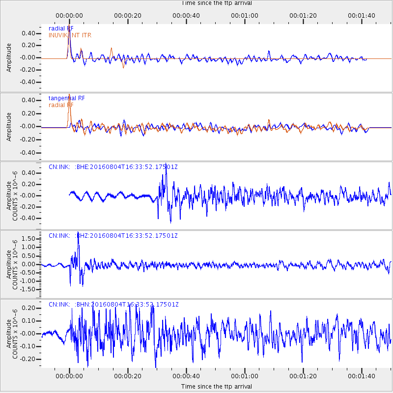
INK INUVIK, NT - Earthquake Result Viewer
*The percent match for this event was below the threshold and hence no stack was calculated.
| Earthquake location: |
Volcano Islands, Japan Region |
| Earthquake latitude/longitude: |
24.9/142.0 |
| Earthquake time(UTC): |
2016/08/04 (217) 16:24:33 GMT |
| Earthquake Depth: |
510 km |
| Earthquake Magnitude: |
6.3 MWW, 6.2 MWC, 6.3 MWB, 6.3 MWC |
| Earthquake Catalog/Contributor: |
NEIC PDE/NEIC COMCAT |
|
| Network: |
CN Canadian National Seismograph Network |
| Station: |
INK INUVIK, NT |
| Lat/Lon: |
68.31 N/133.53 W |
| Elevation: |
44 m |
|
| Distance: |
65.0 deg |
| Az: |
24.09 deg |
| Baz: |
274.726 deg |
| Ray Param: |
$rayparam |
*The percent match for this event was below the threshold and hence was not used in the summary stack. |
|
| Radial Match: |
79.87271 % |
| Radial Bump: |
400 |
| Transverse Match: |
67.0269 % |
| Transverse Bump: |
400 |
| SOD ConfigId: |
11737051 |
| Insert Time: |
2019-04-25 05:50:46.982 +0000 |
| GWidth: |
2.5 |
| Max Bumps: |
400 |
| Tol: |
0.001 |
|
Signal To Noise
| Channel | StoN | STA | LTA |
| CN:INK: :BHZ:20160804T16:33:52.17501Z | 14.890172 | 6.681018E-7 | 4.4868642E-8 |
| CN:INK: :BHN:20160804T16:33:52.17501Z | 2.3646698 | 8.3465544E-8 | 3.5296914E-8 |
| CN:INK: :BHE:20160804T16:33:52.17501Z | 5.404284 | 2.3025795E-7 | 4.2606562E-8 |
| Arrivals |
| Ps | |
| PpPs | |
| PsPs/PpSs | |


