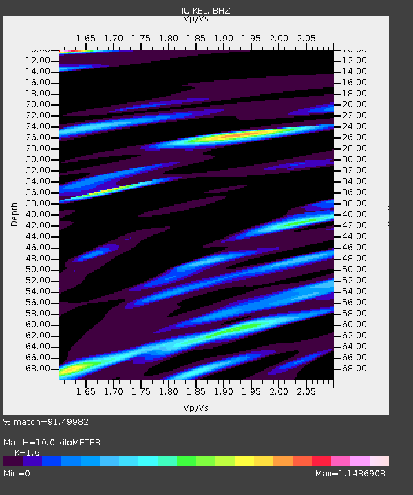
KBL Kabul, Afghanistan - Earthquake Result Viewer
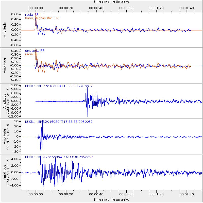
Earthquake location: Volcano Islands, Japan Region
Earthquake latitude/longitude: 24.9/142.0
Earthquake time(UTC): 2016/08/04 (217) 16:24:33 GMT
Earthquake Depth: 510 km
Earthquake Magnitude: 6.3 MWW, 6.2 MWC, 6.3 MWB, 6.3 MWC
Earthquake Catalog/Contributor: NEIC PDE/NEIC COMCAT
Network: IU Global Seismograph Network (GSN - IRIS/USGS)
Station: KBL Kabul, Afghanistan
Lat/Lon: 34.54 N/69.04 E
Elevation: 1920 m
Distance: 62.9 deg
Az: 297.502 deg
Baz: 77.265 deg
Ray Param: 0.05808581
Estimated Moho Depth: 10.0 km
Estimated Crust Vp/Vs: 1.60
Assumed Crust Vp: 6.641 km/s
Estimated Crust Vs: 4.15 km/s
Estimated Crust Poisson's Ratio: 0.18
Radial Match: 91.49982 %
Radial Bump: 400
Transverse Match: 83.73374 %
Transverse Bump: 400
SOD ConfigId: 11737051
Insert Time: 2019-04-25 05:52:08.399 +0000
GWidth: 2.5
Max Bumps: 400
Tol: 0.001

Signal To Noise

ChannelStoNSTALTA
IU:KBL: :BHZ:20160804T16:33:38.295005Z266.011541.0525386E-53.9567404E-8
IU:KBL: :BHN:20160804T16:33:38.295005Z42.6929171.7017458E-63.9860144E-8
IU:KBL: :BHE:20160804T16:33:38.295005Z112.836244.0912864E-63.625862E-8
Arrivals
Ps0.9 SECOND
PpPs3.7 SECOND
PsPs/PpSs4.7 SECOND