You are here: Home > Network List > US - United States National Seismic Network Stations List
> Station LBNH Lisbon, New Hampshire, USA > Earthquake Result Viewer
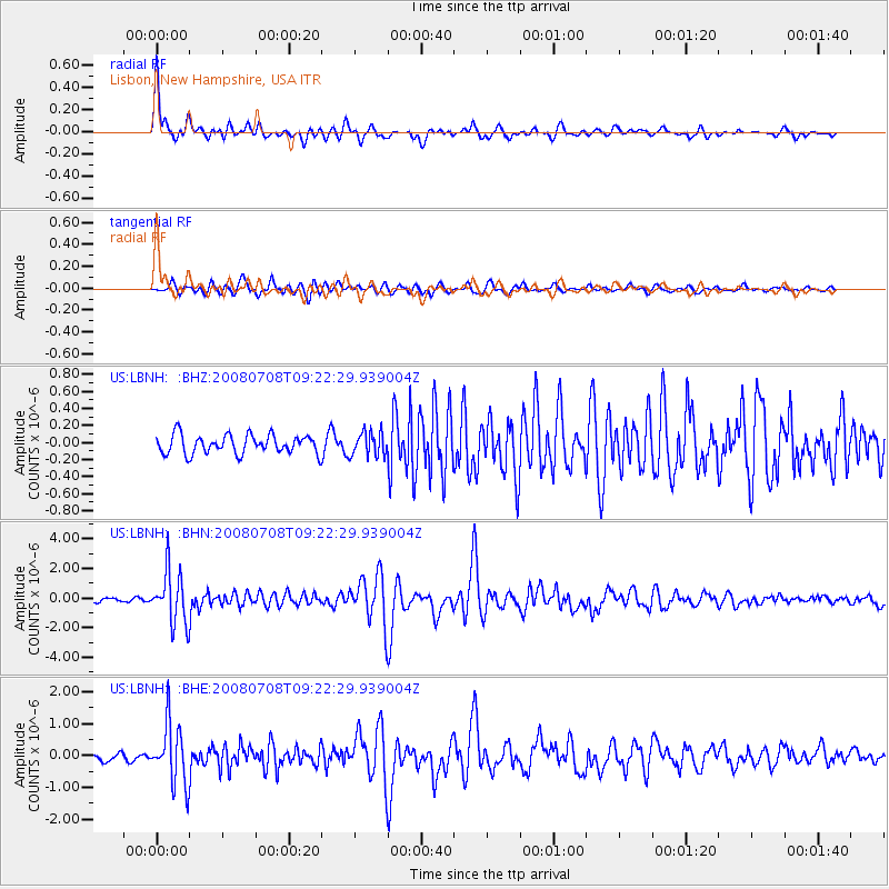
LBNH Lisbon, New Hampshire, USA - Earthquake Result Viewer

| Earthquake location: |
Southern Peru |
| Earthquake latitude/longitude: |
-16.0/-71.7 |
| Earthquake time(UTC): |
2008/07/08 (190) 09:13:07 GMT |
| Earthquake Depth: |
123 km |
| Earthquake Magnitude: |
5.8 MB, 6.2 MW, 6.2 MW |
| Earthquake Catalog/Contributor: |
WHDF/NEIC |
|
| Network: |
US United States National Seismic Network |
| Station: |
LBNH Lisbon, New Hampshire, USA |
| Lat/Lon: |
44.24 N/71.93 W |
| Elevation: |
367 m |
|
| Distance: |
59.9 deg |
| Az: |
359.852 deg |
| Baz: |
179.802 deg |
| Ray Param: |
0.061497945 |
| Estimated Moho Depth: |
62.5 km |
| Estimated Crust Vp/Vs: |
2.10 |
| Assumed Crust Vp: |
6.419 km/s |
| Estimated Crust Vs: |
3.06 km/s |
| Estimated Crust Poisson's Ratio: |
0.35 |
|
| Radial Match: |
92.196 % |
| Radial Bump: |
400 |
| Transverse Match: |
79.82949 % |
| Transverse Bump: |
400 |
| SOD ConfigId: |
2504 |
| Insert Time: |
2010-03-05 05:57:51.342 +0000 |
| GWidth: |
2.5 |
| Max Bumps: |
400 |
| Tol: |
0.001 |
|
Signal To Noise
| Channel | StoN | STA | LTA |
| US:LBNH: :BHN:20080708T09:22:29.939004Z | 11.760433 | 1.7797538E-6 | 1.5133404E-7 |
| US:LBNH: :BHE:20080708T09:22:29.939004Z | 6.6332545 | 9.4146714E-7 | 1.4193141E-7 |
| US:LBNH: :BHZ:20080708T09:22:29.939004Z | 1.2445905 | 1.3754745E-7 | 1.10516226E-7 |
| Arrivals |
| Ps | 11 SECOND |
| PpPs | 29 SECOND |
| PsPs/PpSs | 40 SECOND |


