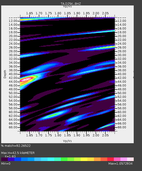
D25K Kavik River, AK, USA - Earthquake Result Viewer
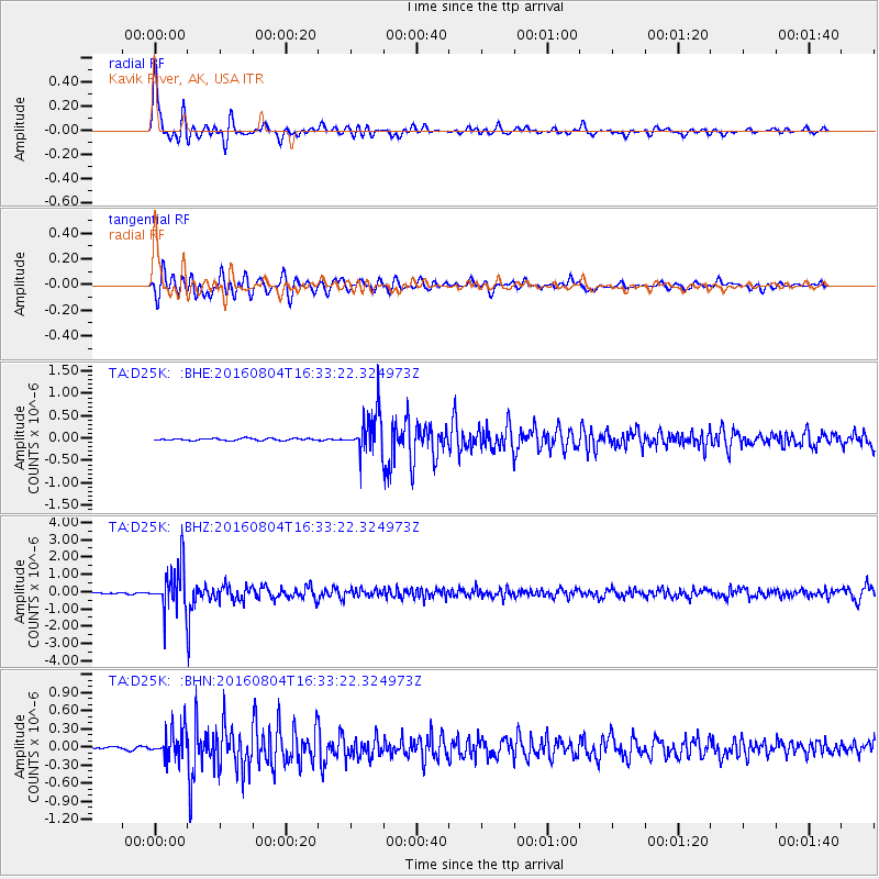
Earthquake location: Volcano Islands, Japan Region
Earthquake latitude/longitude: 24.9/142.0
Earthquake time(UTC): 2016/08/04 (217) 16:24:33 GMT
Earthquake Depth: 510 km
Earthquake Magnitude: 6.3 MWW, 6.2 MWC, 6.3 MWB, 6.3 MWC
Earthquake Catalog/Contributor: NEIC PDE/NEIC COMCAT
Network: TA USArray Transportable Network (new EarthScope stations)
Station: D25K Kavik River, AK, USA
Lat/Lon: 69.32 N/146.38 W
Elevation: 770 m
Distance: 60.4 deg
Az: 22.807 deg
Baz: 262.16 deg
Ray Param: 0.05961075
Estimated Moho Depth: 42.5 km
Estimated Crust Vp/Vs: 1.63
Assumed Crust Vp: 6.378 km/s
Estimated Crust Vs: 3.913 km/s
Estimated Crust Poisson's Ratio: 0.20
Radial Match: 92.26522 %
Radial Bump: 400
Transverse Match: 83.606804 %
Transverse Bump: 400
SOD ConfigId: 11737051
Insert Time: 2019-04-25 05:54:34.127 +0000
GWidth: 2.5
Max Bumps: 400
Tol: 0.001

Signal To Noise

ChannelStoNSTALTA
TA:D25K: :BHZ:20160804T16:33:22.324973Z31.9778231.2050621E-63.768431E-8
TA:D25K: :BHN:20160804T16:33:22.324973Z7.0566832.4787406E-73.5126142E-8
TA:D25K: :BHE:20160804T16:33:22.324973Z20.1750164.5368333E-72.2487384E-8
Arrivals
Ps4.4 SECOND
PpPs17 SECOND
PsPs/PpSs21 SECOND