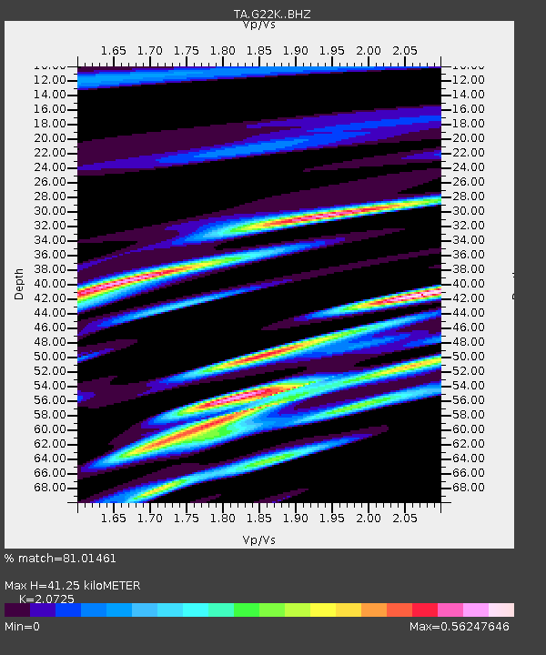
G22K Bettles, AK, USA - Earthquake Result Viewer

Earthquake location: Volcano Islands, Japan Region
Earthquake latitude/longitude: 24.9/142.0
Earthquake time(UTC): 2016/08/04 (217) 16:24:33 GMT
Earthquake Depth: 510 km
Earthquake Magnitude: 6.3 MWW, 6.2 MWC, 6.3 MWB, 6.3 MWC
Earthquake Catalog/Contributor: NEIC PDE/NEIC COMCAT
Network: TA USArray Transportable Network (new EarthScope stations)
Station: G22K Bettles, AK, USA
Lat/Lon: 66.92 N/151.51 W
Elevation: 205 m
Distance: 58.1 deg
Az: 25.198 deg
Baz: 258.623 deg
Ray Param: 0.06103497
Estimated Moho Depth: 41.25 km
Estimated Crust Vp/Vs: 2.07
Assumed Crust Vp: 6.577 km/s
Estimated Crust Vs: 3.173 km/s
Estimated Crust Poisson's Ratio: 0.35
Radial Match: 81.01461 %
Radial Bump: 363
Transverse Match: 73.44851 %
Transverse Bump: 400
SOD ConfigId: 11737051
Insert Time: 2019-04-25 05:54:45.135 +0000
GWidth: 2.5
Max Bumps: 400
Tol: 0.001

Signal To Noise

ChannelStoNSTALTA
TA:G22K: :BHZ:20160804T16:33:06.949973Z16.6745131.1096444E-66.654733E-8
TA:G22K: :BHN:20160804T16:33:06.949973Z6.7803255.326001E-77.8550826E-8
TA:G22K: :BHE:20160804T16:33:06.949973Z10.9548626.927039E-76.3232555E-8
Arrivals
Ps7.0 SECOND
PpPs18 SECOND
PsPs/PpSs26 SECOND