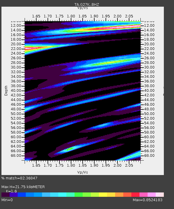
G27K Doyon Strip, AK, USA - Earthquake Result Viewer

Earthquake location: Volcano Islands, Japan Region
Earthquake latitude/longitude: 24.9/142.0
Earthquake time(UTC): 2016/08/04 (217) 16:24:33 GMT
Earthquake Depth: 510 km
Earthquake Magnitude: 6.3 MWW, 6.2 MWC, 6.3 MWB, 6.3 MWC
Earthquake Catalog/Contributor: NEIC PDE/NEIC COMCAT
Network: TA USArray Transportable Network (new EarthScope stations)
Station: G27K Doyon Strip, AK, USA
Lat/Lon: 66.81 N/141.65 W
Elevation: 686 m
Distance: 62.0 deg
Az: 25.85 deg
Baz: 268.003 deg
Ray Param: 0.05864599
Estimated Moho Depth: 21.75 km
Estimated Crust Vp/Vs: 1.60
Assumed Crust Vp: 6.577 km/s
Estimated Crust Vs: 4.11 km/s
Estimated Crust Poisson's Ratio: 0.18
Radial Match: 82.36847 %
Radial Bump: 400
Transverse Match: 66.84319 %
Transverse Bump: 400
SOD ConfigId: 11737051
Insert Time: 2019-04-25 05:54:48.344 +0000
GWidth: 2.5
Max Bumps: 400
Tol: 0.001

Signal To Noise

ChannelStoNSTALTA
TA:G27K: :BHZ:20160804T16:33:32.474998Z17.385655.8625363E-73.3720546E-8
TA:G27K: :BHN:20160804T16:33:32.474998Z1.25341053.8783874E-83.0942676E-8
TA:G27K: :BHE:20160804T16:33:32.474998Z6.35554462.6442547E-74.1605475E-8
Arrivals
Ps2.1 SECOND
PpPs8.2 SECOND
PsPs/PpSs10 SECOND