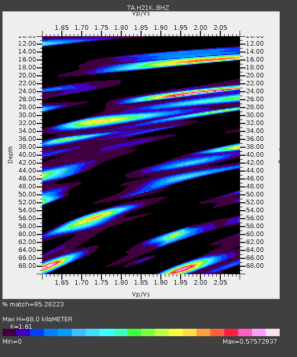
H21K Melozitna River, AK, USA - Earthquake Result Viewer

Earthquake location: Volcano Islands, Japan Region
Earthquake latitude/longitude: 24.9/142.0
Earthquake time(UTC): 2016/08/04 (217) 16:24:33 GMT
Earthquake Depth: 510 km
Earthquake Magnitude: 6.3 MWW, 6.2 MWC, 6.3 MWB, 6.3 MWC
Earthquake Catalog/Contributor: NEIC PDE/NEIC COMCAT
Network: TA USArray Transportable Network (new EarthScope stations)
Station: H21K Melozitna River, AK, USA
Lat/Lon: 65.66 N/152.80 W
Elevation: 520 m
Distance: 57.3 deg
Az: 26.544 deg
Baz: 258.155 deg
Ray Param: 0.061520126
Estimated Moho Depth: 68.0 km
Estimated Crust Vp/Vs: 1.61
Assumed Crust Vp: 6.566 km/s
Estimated Crust Vs: 4.078 km/s
Estimated Crust Poisson's Ratio: 0.19
Radial Match: 95.28223 %
Radial Bump: 400
Transverse Match: 88.4412 %
Transverse Bump: 400
SOD ConfigId: 11737051
Insert Time: 2019-04-25 05:54:51.324 +0000
GWidth: 2.5
Max Bumps: 400
Tol: 0.001

Signal To Noise

ChannelStoNSTALTA
TA:H21K: :BHZ:20160804T16:33:01.724998Z42.0353781.3742638E-63.269303E-8
TA:H21K: :BHN:20160804T16:33:01.724998Z3.21858841.4726514E-74.5754575E-8
TA:H21K: :BHE:20160804T16:33:01.724998Z21.8770565.657704E-72.5861357E-8
Arrivals
Ps6.7 SECOND
PpPs26 SECOND
PsPs/PpSs32 SECOND