You are here: Home > Network List > TA - USArray Transportable Network (new EarthScope stations) Stations List
> Station I23K Minto, Yukon-Koyukuk, AK, USA > Earthquake Result Viewer
I23K Minto, Yukon-Koyukuk, AK, USA - Earthquake Result Viewer
| Earthquake location: |
Volcano Islands, Japan Region |
| Earthquake latitude/longitude: |
24.9/142.0 |
| Earthquake time(UTC): |
2016/08/04 (217) 16:24:33 GMT |
| Earthquake Depth: |
510 km |
| Earthquake Magnitude: |
6.3 MWW, 6.2 MWC, 6.3 MWB, 6.3 MWC |
| Earthquake Catalog/Contributor: |
NEIC PDE/NEIC COMCAT |
|
| Network: |
TA USArray Transportable Network (new EarthScope stations) |
| Station: |
I23K Minto, Yukon-Koyukuk, AK, USA |
| Lat/Lon: |
65.15 N/149.36 W |
| Elevation: |
149 m |
|
| Distance: |
58.7 deg |
| Az: |
27.434 deg |
| Baz: |
261.755 deg |
| Ray Param: |
0.06069077 |
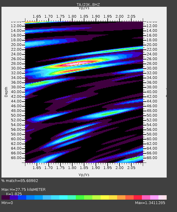
| Estimated Moho Depth: |
27.75 km |
| Estimated Crust Vp/Vs: |
1.83 |
| Assumed Crust Vp: |
6.566 km/s |
| Estimated Crust Vs: |
3.598 km/s |
| Estimated Crust Poisson's Ratio: |
0.29 |
|
| Radial Match: |
85.68982 % |
| Radial Bump: |
400 |
| Transverse Match: |
74.58783 % |
| Transverse Bump: |
400 |
| SOD ConfigId: |
11737051 |
| Insert Time: |
2019-04-25 05:54:57.960 +0000 |
| GWidth: |
2.5 |
| Max Bumps: |
400 |
| Tol: |
0.001 |
|
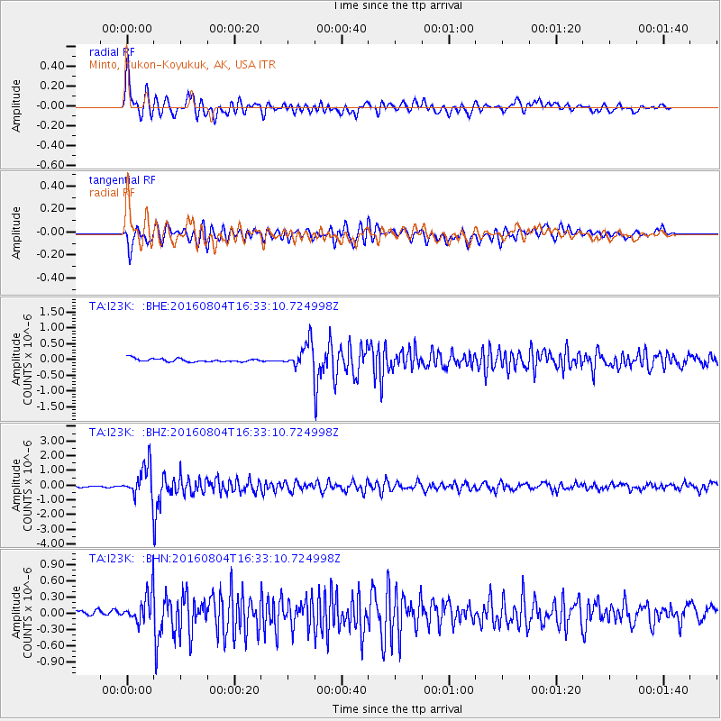
Signal To Noise
| Channel | StoN | STA | LTA |
| TA:I23K: :BHZ:20160804T16:33:10.724998Z | 22.186342 | 1.0617476E-6 | 4.7855913E-8 |
| TA:I23K: :BHN:20160804T16:33:10.724998Z | 3.5346205 | 2.8201777E-7 | 7.9787284E-8 |
| TA:I23K: :BHE:20160804T16:33:10.724998Z | 7.5890694 | 3.967948E-7 | 5.2285042E-8 |
| Arrivals |
| Ps | 3.7 SECOND |
| PpPs | 11 SECOND |
| PsPs/PpSs | 15 SECOND |


