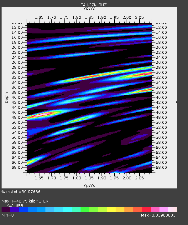
K27K Chicken, AK, USA - Earthquake Result Viewer

Earthquake location: Volcano Islands, Japan Region
Earthquake latitude/longitude: 24.9/142.0
Earthquake time(UTC): 2016/08/04 (217) 16:24:33 GMT
Earthquake Depth: 510 km
Earthquake Magnitude: 6.3 MWW, 6.2 MWC, 6.3 MWB, 6.3 MWC
Earthquake Catalog/Contributor: NEIC PDE/NEIC COMCAT
Network: TA USArray Transportable Network (new EarthScope stations)
Station: K27K Chicken, AK, USA
Lat/Lon: 64.03 N/142.08 W
Elevation: 389 m
Distance: 61.7 deg
Az: 29.01 deg
Baz: 269.113 deg
Ray Param: 0.05879736
Estimated Moho Depth: 46.75 km
Estimated Crust Vp/Vs: 1.65
Assumed Crust Vp: 6.566 km/s
Estimated Crust Vs: 3.967 km/s
Estimated Crust Poisson's Ratio: 0.21
Radial Match: 89.07666 %
Radial Bump: 400
Transverse Match: 70.21791 %
Transverse Bump: 400
SOD ConfigId: 11737051
Insert Time: 2019-04-25 05:55:11.582 +0000
GWidth: 2.5
Max Bumps: 400
Tol: 0.001

Signal To Noise

ChannelStoNSTALTA
TA:K27K: :BHZ:20160804T16:33:30.875022Z22.9638738.754242E-73.81218E-8
TA:K27K: :BHN:20160804T16:33:30.875022Z2.0034467.482933E-83.7350308E-8
TA:K27K: :BHE:20160804T16:33:30.875022Z15.5324884.2664513E-72.7467921E-8
Arrivals
Ps4.9 SECOND
PpPs18 SECOND
PsPs/PpSs23 SECOND