L29M Grand Valley Creek, YT, CAN - Earthquake Result Viewer
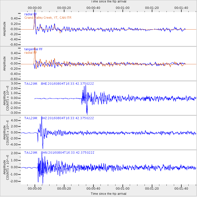
Earthquake location: Volcano Islands, Japan Region
Earthquake latitude/longitude: 24.9/142.0
Earthquake time(UTC): 2016/08/04 (217) 16:24:33 GMT
Earthquake Depth: 510 km
Earthquake Magnitude: 6.3 MWW, 6.2 MWC, 6.3 MWB, 6.3 MWC
Earthquake Catalog/Contributor: NEIC PDE/NEIC COMCAT
Network: TA USArray Transportable Network (new EarthScope stations)
Station: L29M Grand Valley Creek, YT, CAN
Lat/Lon: 63.11 N/138.13 W
Elevation: 918 m
Distance: 63.5 deg
Az: 30.012 deg
Baz: 273.103 deg
Ray Param: 0.05768123
Estimated Moho Depth: 27.25 km
Estimated Crust Vp/Vs: 1.88
Assumed Crust Vp: 6.566 km/s
Estimated Crust Vs: 3.493 km/s
Estimated Crust Poisson's Ratio: 0.30
Radial Match: 87.9315 %
Radial Bump: 400
Transverse Match: 80.66931 %
Transverse Bump: 400
SOD ConfigId: 11737051
Insert Time: 2019-04-25 05:55:17.991 +0000
GWidth: 2.5
Max Bumps: 400
Tol: 0.001

Signal To Noise

ChannelStoNSTALTA
TA:L29M: :BHZ:20160804T16:33:42.375022Z18.684911.4191411E-67.5951185E-8
TA:L29M: :BHN:20160804T16:33:42.375022Z16.1100166.5261816E-74.0510088E-8
TA:L29M: :BHE:20160804T16:33:42.375022Z19.1547977.9323416E-74.1411777E-8
Arrivals
Ps3.8 SECOND
PpPs11 SECOND
PsPs/PpSs15 SECOND