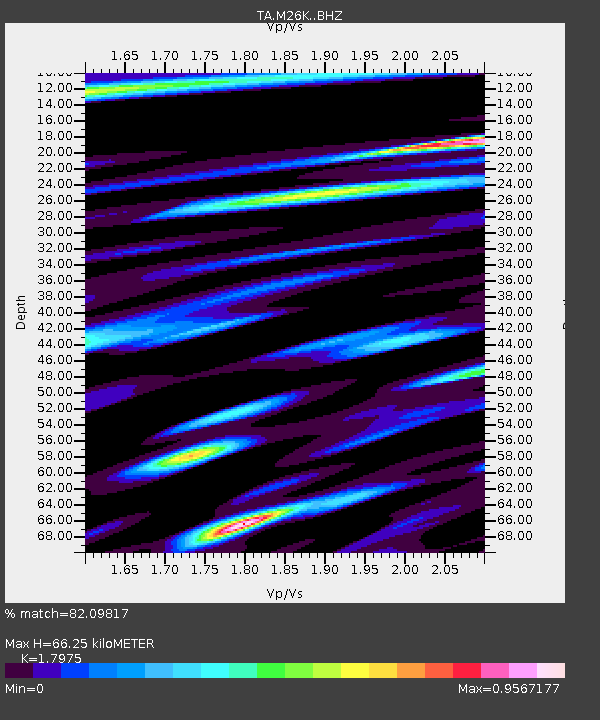
M26K Nabesna, AK, USA - Earthquake Result Viewer

Earthquake location: Volcano Islands, Japan Region
Earthquake latitude/longitude: 24.9/142.0
Earthquake time(UTC): 2016/08/04 (217) 16:24:33 GMT
Earthquake Depth: 510 km
Earthquake Magnitude: 6.3 MWW, 6.2 MWC, 6.3 MWB, 6.3 MWC
Earthquake Catalog/Contributor: NEIC PDE/NEIC COMCAT
Network: TA USArray Transportable Network (new EarthScope stations)
Station: M26K Nabesna, AK, USA
Lat/Lon: 62.40 N/143.00 W
Elevation: 888 m
Distance: 61.3 deg
Az: 30.863 deg
Baz: 269.176 deg
Ray Param: 0.05906884
Estimated Moho Depth: 66.25 km
Estimated Crust Vp/Vs: 1.80
Assumed Crust Vp: 6.566 km/s
Estimated Crust Vs: 3.653 km/s
Estimated Crust Poisson's Ratio: 0.28
Radial Match: 82.09817 %
Radial Bump: 400
Transverse Match: 78.905716 %
Transverse Bump: 400
SOD ConfigId: 11737051
Insert Time: 2019-04-25 05:55:22.777 +0000
GWidth: 2.5
Max Bumps: 400
Tol: 0.001

Signal To Noise

ChannelStoNSTALTA
TA:M26K: :BHZ:20160804T16:33:27.974998Z19.4889938.6483954E-74.4375795E-8
TA:M26K: :BHN:20160804T16:33:27.974998Z5.7754421.8731093E-73.243231E-8
TA:M26K: :BHE:20160804T16:33:27.974998Z13.3938294.5535919E-73.3997683E-8
Arrivals
Ps8.4 SECOND
PpPs27 SECOND
PsPs/PpSs35 SECOND