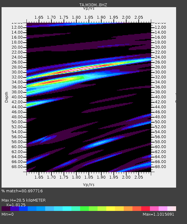
M30M Minto, Yukon, CA - Earthquake Result Viewer

Earthquake location: Volcano Islands, Japan Region
Earthquake latitude/longitude: 24.9/142.0
Earthquake time(UTC): 2016/08/04 (217) 16:24:33 GMT
Earthquake Depth: 510 km
Earthquake Magnitude: 6.3 MWW, 6.2 MWC, 6.3 MWB, 6.3 MWC
Earthquake Catalog/Contributor: NEIC PDE/NEIC COMCAT
Network: TA USArray Transportable Network (new EarthScope stations)
Station: M30M Minto, Yukon, CA
Lat/Lon: 62.58 N/136.79 W
Elevation: 782 m
Distance: 64.1 deg
Az: 30.561 deg
Baz: 274.532 deg
Ray Param: 0.05727054
Estimated Moho Depth: 28.5 km
Estimated Crust Vp/Vs: 1.81
Assumed Crust Vp: 6.566 km/s
Estimated Crust Vs: 3.623 km/s
Estimated Crust Poisson's Ratio: 0.28
Radial Match: 80.697716 %
Radial Bump: 400
Transverse Match: 73.00996 %
Transverse Bump: 400
SOD ConfigId: 11737051
Insert Time: 2019-04-25 05:55:23.498 +0000
GWidth: 2.5
Max Bumps: 400
Tol: 0.001

Signal To Noise

ChannelStoNSTALTA
TA:M30M: :BHZ:20160804T16:33:46.500022Z13.734247.761628E-75.6512977E-8
TA:M30M: :BHN:20160804T16:33:46.500022Z1.82150238.680003E-84.765299E-8
TA:M30M: :BHE:20160804T16:33:46.500022Z7.6793863.5661625E-74.6438117E-8
Arrivals
Ps3.7 SECOND
PpPs12 SECOND
PsPs/PpSs15 SECOND