You are here: Home > Network List > US - United States National Seismic Network Stations List
> Station LBNH Lisbon, New Hampshire, USA > Earthquake Result Viewer
LBNH Lisbon, New Hampshire, USA - Earthquake Result Viewer
| Earthquake location: |
Ecuador |
| Earthquake latitude/longitude: |
-1.3/-77.5 |
| Earthquake time(UTC): |
1999/08/28 (240) 12:40:06 GMT |
| Earthquake Depth: |
196 km |
| Earthquake Magnitude: |
5.9 MB, 6.3 MW, 6.2 MW |
| Earthquake Catalog/Contributor: |
WHDF/NEIC |
|
| Network: |
US United States National Seismic Network |
| Station: |
LBNH Lisbon, New Hampshire, USA |
| Lat/Lon: |
44.24 N/71.93 W |
| Elevation: |
367 m |
|
| Distance: |
45.6 deg |
| Az: |
5.657 deg |
| Baz: |
187.88 deg |
| Ray Param: |
0.07043452 |
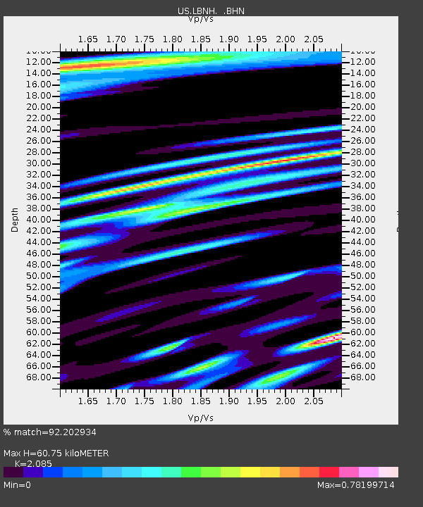
| Estimated Moho Depth: |
60.75 km |
| Estimated Crust Vp/Vs: |
2.09 |
| Assumed Crust Vp: |
6.419 km/s |
| Estimated Crust Vs: |
3.079 km/s |
| Estimated Crust Poisson's Ratio: |
0.35 |
|
| Radial Match: |
92.202934 % |
| Radial Bump: |
358 |
| Transverse Match: |
84.64583 % |
| Transverse Bump: |
400 |
| SOD ConfigId: |
110177 |
| Insert Time: |
2010-03-05 05:58:22.857 +0000 |
| GWidth: |
2.5 |
| Max Bumps: |
400 |
| Tol: |
0.001 |
|

Signal To Noise
| Channel | StoN | STA | LTA |
| US:LBNH: :BHN:19990828T12:47:36.149015Z | 11.170562 | 1.6462693E-6 | 1.4737569E-7 |
| US:LBNH: :BHE:19990828T12:47:36.149015Z | 2.3429832 | 3.051895E-7 | 1.302568E-7 |
| US:LBNH: :BHZ:19990828T12:47:36.149015Z | 23.367504 | 3.3593178E-6 | 1.4376023E-7 |
| Arrivals |
| Ps | 11 SECOND |
| PpPs | 28 SECOND |
| PsPs/PpSs | 39 SECOND |


