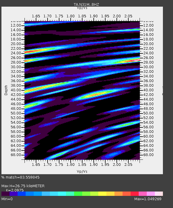
N31M Braeburn, Yukon, CA - Earthquake Result Viewer

Earthquake location: Volcano Islands, Japan Region
Earthquake latitude/longitude: 24.9/142.0
Earthquake time(UTC): 2016/08/04 (217) 16:24:33 GMT
Earthquake Depth: 510 km
Earthquake Magnitude: 6.3 MWW, 6.2 MWC, 6.3 MWB, 6.3 MWC
Earthquake Catalog/Contributor: NEIC PDE/NEIC COMCAT
Network: TA USArray Transportable Network (new EarthScope stations)
Station: N31M Braeburn, Yukon, CA
Lat/Lon: 61.49 N/135.78 W
Elevation: 716 m
Distance: 64.7 deg
Az: 31.72 deg
Baz: 275.927 deg
Ray Param: 0.0569099
Estimated Moho Depth: 26.75 km
Estimated Crust Vp/Vs: 2.10
Assumed Crust Vp: 6.419 km/s
Estimated Crust Vs: 3.06 km/s
Estimated Crust Poisson's Ratio: 0.35
Radial Match: 83.559845 %
Radial Bump: 400
Transverse Match: 67.21518 %
Transverse Bump: 400
SOD ConfigId: 11737051
Insert Time: 2019-04-25 05:55:32.276 +0000
GWidth: 2.5
Max Bumps: 400
Tol: 0.001

Signal To Noise

ChannelStoNSTALTA
TA:N31M: :BHZ:20160804T16:33:50.149985Z15.7400511.169942E-67.432898E-8
TA:N31M: :BHN:20160804T16:33:50.149985Z1.63337351.5162767E-79.283099E-8
TA:N31M: :BHE:20160804T16:33:50.149985Z8.1858886.698413E-78.182879E-8
Arrivals
Ps4.7 SECOND
PpPs12 SECOND
PsPs/PpSs17 SECOND