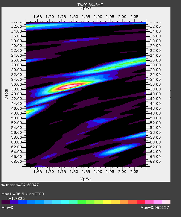
O18K Koktuh Hills, AK, USA - Earthquake Result Viewer

Earthquake location: Volcano Islands, Japan Region
Earthquake latitude/longitude: 24.9/142.0
Earthquake time(UTC): 2016/08/04 (217) 16:24:33 GMT
Earthquake Depth: 510 km
Earthquake Magnitude: 6.3 MWW, 6.2 MWC, 6.3 MWB, 6.3 MWC
Earthquake Catalog/Contributor: NEIC PDE/NEIC COMCAT
Network: TA USArray Transportable Network (new EarthScope stations)
Station: O18K Koktuh Hills, AK, USA
Lat/Lon: 59.85 N/155.21 W
Elevation: 544 m
Distance: 55.1 deg
Az: 33.165 deg
Baz: 259.702 deg
Ray Param: 0.062899075
Estimated Moho Depth: 36.5 km
Estimated Crust Vp/Vs: 1.78
Assumed Crust Vp: 6.438 km/s
Estimated Crust Vs: 3.612 km/s
Estimated Crust Poisson's Ratio: 0.27
Radial Match: 94.60047 %
Radial Bump: 318
Transverse Match: 89.411095 %
Transverse Bump: 400
SOD ConfigId: 11737051
Insert Time: 2019-04-25 05:55:34.470 +0000
GWidth: 2.5
Max Bumps: 400
Tol: 0.001

Signal To Noise

ChannelStoNSTALTA
TA:O18K: :BHZ:20160804T16:32:46.499991Z33.0646362.403485E-67.2690504E-8
TA:O18K: :BHN:20160804T16:32:46.499991Z7.17303135.150794E-77.180778E-8
TA:O18K: :BHE:20160804T16:32:46.499991Z13.23739057.730416E-75.839834E-8
Arrivals
Ps4.7 SECOND
PpPs15 SECOND
PsPs/PpSs20 SECOND