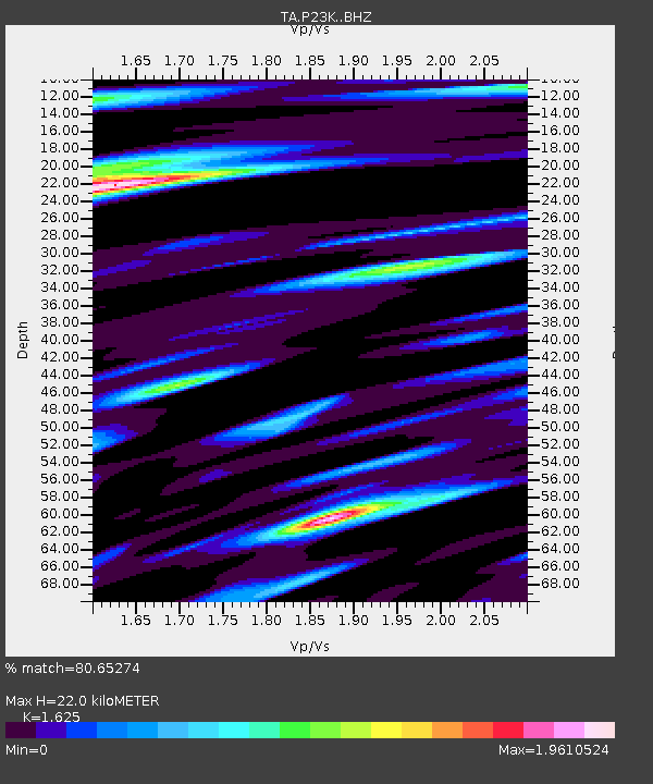
P23K Montague Island, AK, USA - Earthquake Result Viewer

Earthquake location: Volcano Islands, Japan Region
Earthquake latitude/longitude: 24.9/142.0
Earthquake time(UTC): 2016/08/04 (217) 16:24:33 GMT
Earthquake Depth: 510 km
Earthquake Magnitude: 6.3 MWW, 6.2 MWC, 6.3 MWB, 6.3 MWC
Earthquake Catalog/Contributor: NEIC PDE/NEIC COMCAT
Network: TA USArray Transportable Network (new EarthScope stations)
Station: P23K Montague Island, AK, USA
Lat/Lon: 60.00 N/147.40 W
Elevation: 287 m
Distance: 59.1 deg
Az: 33.55 deg
Baz: 266.657 deg
Ray Param: 0.060457177
Estimated Moho Depth: 22.0 km
Estimated Crust Vp/Vs: 1.62
Assumed Crust Vp: 5.989 km/s
Estimated Crust Vs: 3.686 km/s
Estimated Crust Poisson's Ratio: 0.20
Radial Match: 80.65274 %
Radial Bump: 400
Transverse Match: 72.83606 %
Transverse Bump: 400
SOD ConfigId: 11737051
Insert Time: 2019-04-25 05:55:44.024 +0000
GWidth: 2.5
Max Bumps: 400
Tol: 0.001

Signal To Noise

ChannelStoNSTALTA
TA:P23K: :BHZ:20160804T16:33:13.274985Z14.4083682.4981457E-61.7338158E-7
TA:P23K: :BHN:20160804T16:33:13.274985Z2.5194885.334796E-72.1174127E-7
TA:P23K: :BHE:20160804T16:33:13.274985Z4.1771598.683385E-72.0787778E-7
Arrivals
Ps2.4 SECOND
PpPs9.2 SECOND
PsPs/PpSs12 SECOND