You are here: Home > Network List > TA - USArray Transportable Network (new EarthScope stations) Stations List
> Station Q24A Divide, CO, USA > Earthquake Result Viewer
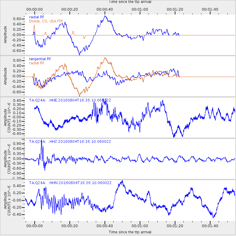
Q24A Divide, CO, USA - Earthquake Result Viewer
*The percent match for this event was below the threshold and hence no stack was calculated.
| Earthquake location: |
Volcano Islands, Japan Region |
| Earthquake latitude/longitude: |
24.9/142.0 |
| Earthquake time(UTC): |
2016/08/04 (217) 16:24:33 GMT |
| Earthquake Depth: |
510 km |
| Earthquake Magnitude: |
6.3 MWW, 6.2 MWC, 6.3 MWB, 6.3 MWC |
| Earthquake Catalog/Contributor: |
NEIC PDE/NEIC COMCAT |
|
| Network: |
TA USArray Transportable Network (new EarthScope stations) |
| Station: |
Q24A Divide, CO, USA |
| Lat/Lon: |
38.96 N/105.15 W |
| Elevation: |
2775 m |
|
| Distance: |
90.7 deg |
| Az: |
45.931 deg |
| Baz: |
303.214 deg |
| Ray Param: |
$rayparam |
*The percent match for this event was below the threshold and hence was not used in the summary stack. |
|
| Radial Match: |
46.28036 % |
| Radial Bump: |
400 |
| Transverse Match: |
47.24537 % |
| Transverse Bump: |
400 |
| SOD ConfigId: |
11737051 |
| Insert Time: |
2019-04-25 05:55:51.009 +0000 |
| GWidth: |
2.5 |
| Max Bumps: |
400 |
| Tol: |
0.001 |
|
Signal To Noise
| Channel | StoN | STA | LTA |
| TA:Q24A: :HHZ:20160804T16:36:10.06002Z | 4.1080317 | 3.4582519E-7 | 8.4182695E-8 |
| TA:Q24A: :HHN:20160804T16:36:10.06002Z | 1.2003306 | 1.4496695E-7 | 1.2077251E-7 |
| TA:Q24A: :HHE:20160804T16:36:10.06002Z | 1.3012699 | 1.8453622E-7 | 1.4181241E-7 |
| Arrivals |
| Ps | |
| PpPs | |
| PsPs/PpSs | |


