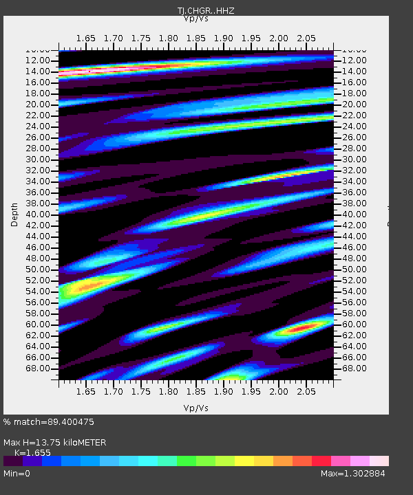
CHGR Chuyangaron, Tajikistan - Earthquake Result Viewer

Earthquake location: Volcano Islands, Japan Region
Earthquake latitude/longitude: 24.9/142.0
Earthquake time(UTC): 2016/08/04 (217) 16:24:33 GMT
Earthquake Depth: 510 km
Earthquake Magnitude: 6.3 MWW, 6.2 MWC, 6.3 MWB, 6.3 MWC
Earthquake Catalog/Contributor: NEIC PDE/NEIC COMCAT
Network: TJ Tajikistan National Seismic Network
Station: CHGR Chuyangaron, Tajikistan
Lat/Lon: 38.66 N/69.16 E
Elevation: 1049 m
Distance: 61.9 deg
Az: 302.022 deg
Baz: 79.428 deg
Ray Param: 0.05866433
Estimated Moho Depth: 13.75 km
Estimated Crust Vp/Vs: 1.65
Assumed Crust Vp: 6.483 km/s
Estimated Crust Vs: 3.917 km/s
Estimated Crust Poisson's Ratio: 0.21
Radial Match: 89.400475 %
Radial Bump: 400
Transverse Match: 73.868324 %
Transverse Bump: 400
SOD ConfigId: 11737051
Insert Time: 2019-04-25 05:56:08.222 +0000
GWidth: 2.5
Max Bumps: 400
Tol: 0.001

Signal To Noise

ChannelStoNSTALTA
TJ:CHGR: :HHZ:20160804T16:33:32.320029Z160.709411.8208917E-51.13303365E-7
TJ:CHGR: :HHN:20160804T16:33:32.320029Z38.589912.6498317E-66.866644E-8
TJ:CHGR: :HHE:20160804T16:33:32.320029Z129.015676.9827056E-65.412293E-8
Arrivals
Ps1.5 SECOND
PpPs5.4 SECOND
PsPs/PpSs6.8 SECOND