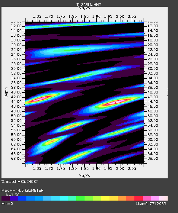
GARM Garm, Tajikistan - Earthquake Result Viewer
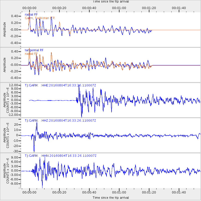
Earthquake location: Volcano Islands, Japan Region
Earthquake latitude/longitude: 24.9/142.0
Earthquake time(UTC): 2016/08/04 (217) 16:24:33 GMT
Earthquake Depth: 510 km
Earthquake Magnitude: 6.3 MWW, 6.2 MWC, 6.3 MWB, 6.3 MWC
Earthquake Catalog/Contributor: NEIC PDE/NEIC COMCAT
Network: TJ Tajikistan National Seismic Network
Station: GARM Garm, Tajikistan
Lat/Lon: 39.00 N/70.32 E
Elevation: 1305 m
Distance: 61.0 deg
Az: 302.224 deg
Baz: 80.248 deg
Ray Param: 0.059253853
Estimated Moho Depth: 44.0 km
Estimated Crust Vp/Vs: 1.98
Assumed Crust Vp: 6.306 km/s
Estimated Crust Vs: 3.185 km/s
Estimated Crust Poisson's Ratio: 0.33
Radial Match: 85.24987 %
Radial Bump: 400
Transverse Match: 82.2753 %
Transverse Bump: 400
SOD ConfigId: 11737051
Insert Time: 2019-04-25 05:56:09.488 +0000
GWidth: 2.5
Max Bumps: 400
Tol: 0.001

Signal To Noise

ChannelStoNSTALTA
TJ:GARM: :HHZ:20160804T16:33:26.110007Z111.67778.8562965E-67.930228E-8
TJ:GARM: :HHN:20160804T16:33:26.110007Z13.7890411.5299545E-61.1095439E-7
TJ:GARM: :HHE:20160804T16:33:26.110007Z32.189953.6683869E-61.1396063E-7
Arrivals
Ps7.1 SECOND
PpPs20 SECOND
PsPs/PpSs27 SECOND