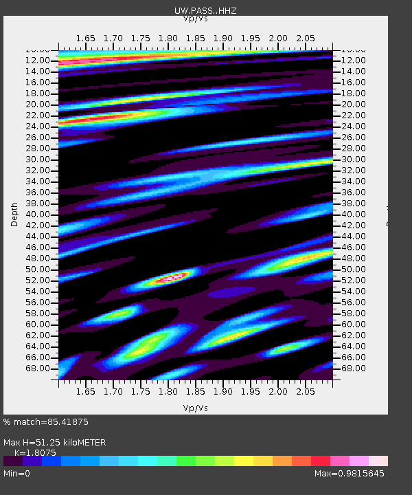
PASS Maple Falls, WA, USA - Earthquake Result Viewer
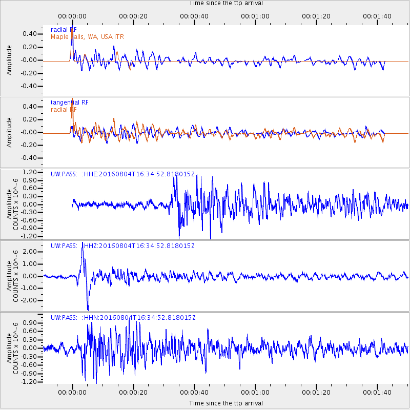
Earthquake location: Volcano Islands, Japan Region
Earthquake latitude/longitude: 24.9/142.0
Earthquake time(UTC): 2016/08/04 (217) 16:24:33 GMT
Earthquake Depth: 510 km
Earthquake Magnitude: 6.3 MWW, 6.2 MWC, 6.3 MWB, 6.3 MWC
Earthquake Catalog/Contributor: NEIC PDE/NEIC COMCAT
Network: UW Pacific Northwest Regional Seismic Network
Station: PASS Maple Falls, WA, USA
Lat/Lon: 49.00 N/122.09 W
Elevation: 174 m
Distance: 75.3 deg
Az: 42.635 deg
Baz: 290.997 deg
Ray Param: 0.050183803
Estimated Moho Depth: 51.25 km
Estimated Crust Vp/Vs: 1.81
Assumed Crust Vp: 6.566 km/s
Estimated Crust Vs: 3.633 km/s
Estimated Crust Poisson's Ratio: 0.28
Radial Match: 85.41875 %
Radial Bump: 400
Transverse Match: 72.99484 %
Transverse Bump: 400
SOD ConfigId: 11737051
Insert Time: 2019-04-25 05:56:43.520 +0000
GWidth: 2.5
Max Bumps: 400
Tol: 0.001

Signal To Noise

ChannelStoNSTALTA
UW:PASS: :HHZ:20160804T16:34:52.818015Z10.5269579.4915634E-79.016437E-8
UW:PASS: :HHN:20160804T16:34:52.818015Z3.60972292.8246583E-77.82514E-8
UW:PASS: :HHE:20160804T16:34:52.818015Z5.14074753.5511374E-76.907823E-8
Arrivals
Ps6.5 SECOND
PpPs21 SECOND
PsPs/PpSs28 SECOND