You are here: Home > Network List > US - United States National Seismic Network Stations List
> Station LBNH Lisbon, New Hampshire, USA > Earthquake Result Viewer
LBNH Lisbon, New Hampshire, USA - Earthquake Result Viewer
| Earthquake location: |
Near Coast Of Peru |
| Earthquake latitude/longitude: |
-17.7/-71.6 |
| Earthquake time(UTC): |
2001/06/26 (177) 04:18:31 GMT |
| Earthquake Depth: |
24 km |
| Earthquake Magnitude: |
6.2 MB, 6.7 MS, 6.8 MW, 6.7 ME |
| Earthquake Catalog/Contributor: |
WHDF/NEIC |
|
| Network: |
US United States National Seismic Network |
| Station: |
LBNH Lisbon, New Hampshire, USA |
| Lat/Lon: |
44.24 N/71.93 W |
| Elevation: |
367 m |
|
| Distance: |
61.7 deg |
| Az: |
359.774 deg |
| Baz: |
179.7 deg |
| Ray Param: |
0.06068719 |
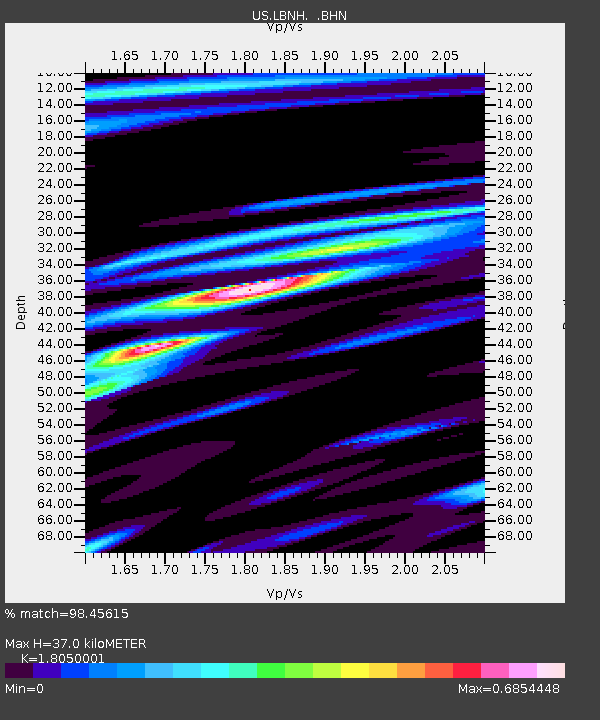
| Estimated Moho Depth: |
37.0 km |
| Estimated Crust Vp/Vs: |
1.81 |
| Assumed Crust Vp: |
6.419 km/s |
| Estimated Crust Vs: |
3.556 km/s |
| Estimated Crust Poisson's Ratio: |
0.28 |
|
| Radial Match: |
98.45615 % |
| Radial Bump: |
344 |
| Transverse Match: |
93.357346 % |
| Transverse Bump: |
400 |
| SOD ConfigId: |
110165 |
| Insert Time: |
2010-03-05 05:59:44.811 +0000 |
| GWidth: |
2.5 |
| Max Bumps: |
400 |
| Tol: |
0.001 |
|

Signal To Noise
| Channel | StoN | STA | LTA |
| US:LBNH: :BHN:20010626T04:28:16.332026Z | 2.1670794 | 1.6852131E-7 | 7.776425E-8 |
| US:LBNH: :BHE:20010626T04:28:16.332026Z | 1.0971571 | 8.3885354E-8 | 7.645701E-8 |
| US:LBNH: :BHZ:20010626T04:28:16.332026Z | 6.8352046 | 4.2139402E-7 | 6.165054E-8 |
| Arrivals |
| Ps | 4.9 SECOND |
| PpPs | 15 SECOND |
| PsPs/PpSs | 20 SECOND |


