You are here: Home > Network List > AK - Alaska Regional Network Stations List
> Station BRLK Bradley Lake > Earthquake Result Viewer
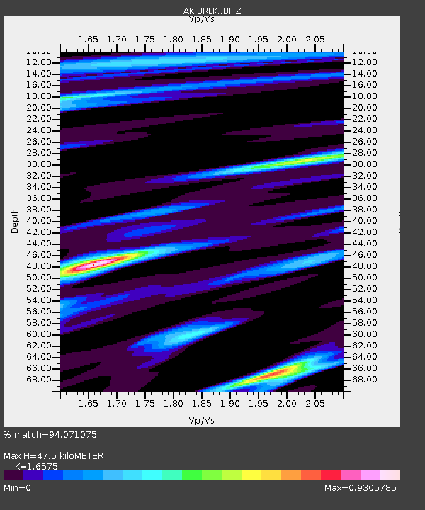
BRLK Bradley Lake - Earthquake Result Viewer
| Earthquake location: |
Southeast Of Loyalty Islands |
| Earthquake latitude/longitude: |
-22.5/173.1 |
| Earthquake time(UTC): |
2016/08/12 (225) 01:26:35 GMT |
| Earthquake Depth: |
10 km |
| Earthquake Magnitude: |
7.2 MWW, 7.6 MI |
| Earthquake Catalog/Contributor: |
NEIC PDE/NEIC COMCAT |
|
| Network: |
AK Alaska Regional Network |
| Station: |
BRLK Bradley Lake |
| Lat/Lon: |
59.75 N/150.91 W |
| Elevation: |
409 m |
|
| Distance: |
87.1 deg |
| Az: |
17.328 deg |
| Baz: |
212.961 deg |
| Ray Param: |
0.043577716 |
| Estimated Moho Depth: |
47.5 km |
| Estimated Crust Vp/Vs: |
1.66 |
| Assumed Crust Vp: |
6.24 km/s |
| Estimated Crust Vs: |
3.765 km/s |
| Estimated Crust Poisson's Ratio: |
0.21 |
|
| Radial Match: |
94.071075 % |
| Radial Bump: |
352 |
| Transverse Match: |
86.899185 % |
| Transverse Bump: |
400 |
| SOD ConfigId: |
11737051 |
| Insert Time: |
2019-04-25 06:03:42.746 +0000 |
| GWidth: |
2.5 |
| Max Bumps: |
400 |
| Tol: |
0.001 |
|

Signal To Noise
| Channel | StoN | STA | LTA |
| AK:BRLK: :BHZ:20160812T01:38:49.447983Z | 7.35216 | 1.0112171E-6 | 1.3754014E-7 |
| AK:BRLK: :BHN:20160812T01:38:49.447983Z | 2.3298 | 2.633098E-7 | 1.130182E-7 |
| AK:BRLK: :BHE:20160812T01:38:49.447983Z | 1.6256756 | 1.9809384E-7 | 1.2185325E-7 |
| Arrivals |
| Ps | 5.1 SECOND |
| PpPs | 20 SECOND |
| PsPs/PpSs | 25 SECOND |


